Schartihöreli (Isenthal)

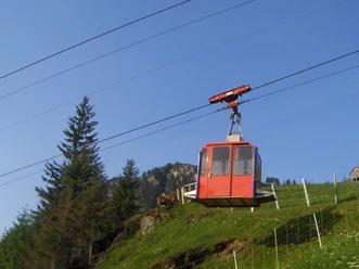
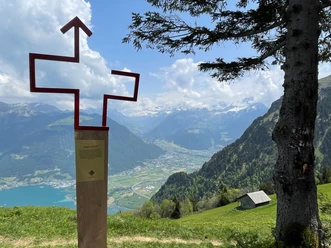
The start of this hike is at the mountain station of the Chlital - Gietisflue cable car. From there, you climb up to the Wanggrat, where you can catch your first view of Lake Uri. Along the ridge, the path leads about 100 meters more in elevation to the summit cross of Schartihöreli. It is worth pausing here for a moment to look around the beautiful mountain world. The first part of the descent is familiar, as it was already the ascent. At the fork, however, you stay on the ridge towards the Hinter Wang alpine hut. From Hinter Wang, you enter the wildlife protection area and the path becomes a bit steeper. At Ronenüti, the descent becomes more gentle again. Soon you reach the valley station of the Musenalp cable car and find yourself back on Chlitalstrasse. You follow it to the starting point of the valley station of the Chlital-Gietisflue cable car.
- 2:10 h
- 5.64 km
- 294 m
- 660 m
- 1,031 m
- 1,690 m
- 659 m
- Start: Mountain station Chlital-Gietisflue Cable Car
- Destination: Valley station Chlital-Gietisflue Cable Car
Good to know
Pavements
Best to visit
Directions
Tour information
Loop Road
Mountain Railway Tour
Nature Highlight
Summit
Equipment
Sturdy hiking boots with a grippy sole, weather-appropriate equipment, topographic national maps (not just smartphone), compass and altimeter are part of the basic equipment.
Additionally, a pocket first aid kit, emergency blanket and mobile phone for emergencies also belong to the basic equipment.
Directions & Parking facilities
Author
Priska Herger
Organization
Verein Urner Wanderwege
Author´s Tip / Recommendation of the author
Safety guidelines
Mountain hiking is demanding.
Knowledge of mountain hazards (rockfall, slip/fall risk, sudden weather changes) is necessary for mountain hiking trails. Sturdy hiking boots with a grippy sole, weather-appropriate equipment, topographic national maps (not just smartphone), compass and altimeter are part of the basic equipment. Additionally, a pocket first aid kit, emergency blanket and mobile phone for emergencies are included in the basic equipment.
It is recommended to make a serious route planning and careful preparation for every hike. The weather in the mountains can change very quickly. Fog can make orientation difficult even in summer. The greatest danger in summer besides heat are thunderstorms. Thunderstorms with heavy rain and hail quickly turn a small brook into a large river, increasing the risk of mudslides and rockfall. Therefore, it is important to interpret the weather forecast during route planning. Warm thunderstorms often come only in the afternoon, but frontal thunderstorms can occur at any time of day. In general, it is worth setting off early in the summer.
Mountain guides are recommended for alpine hiking routes (white-blue-white marked routes).
Hiking leaders are recommended for hikes and mountain hikes; they take care of organization & planning so that guests can simply enjoy the hike.
The Uri hiking planner and the Uri Outdoor app help with the planning. Via GeoAdmin you can find many useful information, such as where pastures with herd protection dogs, suckler cow pastures, and also wildlife quiet zones are located.
Hikers hike at their own risk. The Urner Wanderwege Association is not liable for accidents that occur during this hike.
Map

Nearby

Download GPX file