Snowshoe route 882: Arnisee


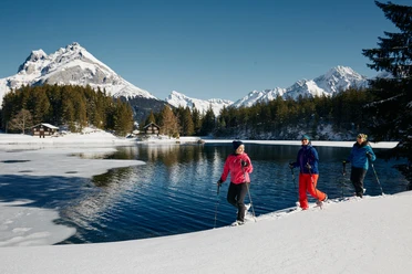
The Intschi-Arnisee aerial cableway takes us within six minutes to an alpine world at 1,368 meters above sea level. The lakeside route leads through the snowy mountain landscape over easy terrain with small ascents and descents. The highlight: the frozen Arnisee with a view of the mighty Bristen. With its uniform, triangular pyramid shape, it is considered the emblem of the canton of Uri par excellence.
Over Vorder Arni, which is also directly accessible by the Amsteg-Arnisee cable car, the trail leads towards Mittelarni. While the snow crunches underfoot, the view wanders over the Reuss valley and to Gross and Chli Windgällen.
Passing huts and stables, you reach the Arnisee again. Finally, a somewhat more demanding additional loop leads further to the mountain chapel, over Torli to Diessenbrunnen, and back to the Intschi-Arnisee mountain station.
- 2:40 h
- 6.62 km
- 241 m
- 242 m
- 1,289 m
- 1,409 m
- 120 m
- Start: Intschi-Arni aerial cableway mountain station
- Destination: Intschi-Arni aerial cableway mountain station
Good to know
Pavements
Best to visit
Directions
Tour information
Loop Road
Stop at an Inn
Equipment
Directions & Parking facilities
Author
Markus Fehlmann
Organization
Verein Urner Wanderwege
Author´s Tip / Recommendation of the author
Map
Nearby
Download GPX file