Steinen - Wildspitz


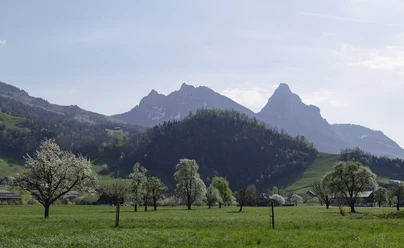
You hike up from the village of Steinen and follow the road west of the church until it turns left towards Stalden. Alternatively, you can also hike west from the SBB station. After about 500 meters, the path turns right over stairs to the Weidli speech therapy school. At the top, walk right around the main building, reach the small street and follow it for a few meters. Then the path turns right into the Nagelwald forest. It is hardly possible to get lost until Stalden. You reach Rossbergstrasse, turn immediately left again, and follow the stream. At the curve, cross over to the lower Bonel and ascend to Bonel, where you cross the cantonal road between Goldau/Steinerberg and Sattel. Then follow the paved agricultural road for a few meters. Where the road makes a wide left curve, leave it to the right. The path then first follows the forest edge, then branches off slightly uphill into the forest. You follow the path, leave the forest, and climb up the forest edge to the natural road. Over meadows and forests, you enter a corner of the Chlosterwald and reach the place with the funny name "Lutzi-Gmeinmärcht." Higher up, you encounter another curiosity, squeezing between rock blocks. This spot is called Ofenloch. On these sections, you hike along the municipal boundary. The path leaves the forest and returns to the paved mountain road towards Obhäg up to the Obhäg chapel. It is worth taking a detour to the alpine inn Geren (left of the Obhäg chapel). For this, continue on the road before the chapel turnoff and then head directly up to the hut. The detour for physical refreshment is only very small. The hiking path returns to the main path. Now the path winds up the alpine pasture and finally reaches the ridge. Here, enjoy the view over the Zug region and the Ägerital. The path now climbs the slope on the left. There are two options: either take the road or a narrow mountain path on the right halfway. This leads to the summit. The view of surrounding peaks is magnificent.
The return route can take you via the Gnipen landslide area to Goldau or you can go down to the chapel and then a little further down turn towards Steinerberg. Through the village, you reach Blattiswald and from there back to Steinen. Remarks: It is an easy mountain hike that only requires some endurance and good footwear. The hike is also suitable for families with children. A detour to the landslide starting area is definitely worthwhile. In the Goldau landslide on September 2, 1806, almost the entire village of Goldau was destroyed; it was one of the greatest natural disasters in Switzerland. It claimed the lives of 457 people. The landslide today is an almost inexhaustible natural experience, with unique flora and fauna.
- 3:20 h
- 7.47 km
- 1,091 m
- 9 m
- 463 m
- 1,553 m
- 1,090 m
- Start: Steinen
- Destination: Wildspitz
Good to know
Pavements
Best to visit
Directions
Tour information
Stop at an Inn
Summit
Equipment
Directions & Parking facilities
Additional information
Author
Erhard Gick
Organization
Schwyzer Wanderwege
Nearby


