Steinmandlipfad Älggialp

The Älggialp and especially the Steimandlipfad offer you peaceful relaxation and varied experiences. You will learn a lot of interesting facts about the area around the geographical center of Switzerland.
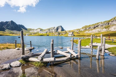
The center is the starting point for the versatile Steimandlipfad, a circular route on the Älggiboden that aims to showcase the beauty of our nature and provide much useful information. Along the Steimandlipfad at 15 selected locations, you will discover what the nearby and wider surroundings of the geographical center of Switzerland have to offer. Walk the 1.5 km path at your leisure. There are interesting notes about the alp itself, flora and fauna, geography, and geology.
Further information
The Älggialp is only accessible on foot or by car.
The information board at the Älggialp mountain restaurant shows the exact starting point of the themed trail.
SPECIAL TRAFFIC REGULATIONS FOR SAT/SUN + HOLIDAYS
On Saturdays, Sundays, and holidays (from midnight onwards), there is one-way traffic from Blatten on the last 5 km.
Uphill drives are allowed on even hours (e.g., 8:00 – 8:40 a.m., you must be at the top by 9:00 a.m. at the latest) and downhill drives on odd hours (e.g., 9:00 – 9:40 a.m., you must be at Blatten by 10:00 a.m. at the latest).
From Sachseln, a narrow, well-paved mountain road leads to the Älggialp. The mountain road can be used by minibuses (up to 16 people).
For passenger transport from Sachseln train station, please contact: Kurt Rohrer – Garage – Hänsigrüt 5 – 6072 Sachseln. Phone 079 709 54 65 (various minibuses)
- 0:29 h
- 1.55 km
- 33 m
- 33 m
- 1,621 m
- 1,642 m
- 21 m
- Start: Geographical Center of Switzerland
- Destination: Geographical Center of Switzerland
Good to know
Pavements
Best to visit
Tour information
Loop Road
Equipment
Author
Obwalden Tourismus
Organization
Obwalden Tourismus
Nearby
Download GPX file