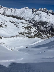
Sustenhorn


The ascent from the Voralp or Chelenalp is probably the most worthy way to approach this giant. Once at the summit cross, you will be happy to have left your tracks in the unique high alpine environment of glacier and rock.
- 4:30 h
- 8.78 km
- 1,803 m
- 90 m
- 1,783 m
- 3,496 m
- 1,713 m
- Start: Voralp/Chelenalp
- Destination: Sustenhorn
Good to know
Best to visit
Directions
Voralp or Chelenalp - Sustenhorn
Tour information
Nature Highlight
Equipment
- Ski touring equipment
- Warm clothing
- Helmet
- Provisions
- Avalanche equipment
- Offline map, GPS
Directions & Parking facilities
In winter, the road to Göscheneralp is closed. However, the Goat Paradise offers a taxi service. Once the road is reopened, it is also available for private car access.
Parking is available directly at the reservoir in Göscheneralp as well as in the village of Göschenen.
In winter, the road to Göscheneralp is closed to public traffic. Once opened, buses run from the Göschenen train station to Göscheneralp. You can find the current timetable at: www.sbb.ch.
Additional information
If you have further questions, feel free to contact: Andermatt holiday region, +41 41 888 71 00, [email protected]
Author
Andermatt-Urserntal Tourismus GmbH
Organization
Région de vacances Andermatt
Safety guidelines
Before starting the route, be sure to check the avalanche bulletin and get information about local conditions.
Nearby