Urmiberg hiking route


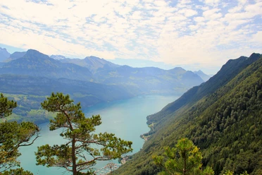
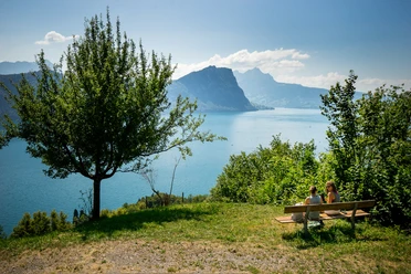
The Urmiberg is considered the “local mountain” of Brunnen. It stretches upright at the eastern end of the village of Brunnen up to 1140 meters elevation. The viewpoints are varied and allow an exciting view over the entire valley basin. From Schwyz with the pointed Mythen to the prominent Fronalpstock and over the village of Brunnen with the monastery in the background, the view extends to Lake Lucerne with the Urnersee and to the Gersauer lake basin. Our hiking route leads gently uphill from the wooden bridge and then quite steeply on a narrow hiking path over roots and stones. After about an hour, you have almost reached the height, and as you continue to follow the “Panoramaweg” sign, it only gently ascends along a natural road. Let your gaze wander in all directions and pause to watch the sailboats. At the “Stöck” farm, the return path begins, now quite steep downhill to the valley station of the Urmiberg cable car. After about 2 ½ hours of hiking time, you have reached the village of Brunnen with its countless restaurants where you can refresh yourself.
- 3:05 h
- 8.19 km
- 314 m
- 314 m
- 433 m
- 746 m
- 313 m
- Start: SBB Brunnen station
- Destination: SGV Brunnen boat station
Good to know
Pavements
Best to visit
Directions
Tour information
Cultural Interesting
Stop at an Inn
Equipment
Directions & Parking facilities
Author
Marcel Truttmann
Organization
Schwyzer Wanderwege
Author´s Tip / Recommendation of the author
Detour to the Hopfräben recreation area.
Safety guidelines
Nearby


