Via Suworow Stage 7: Muotathal – Rear Klöntal


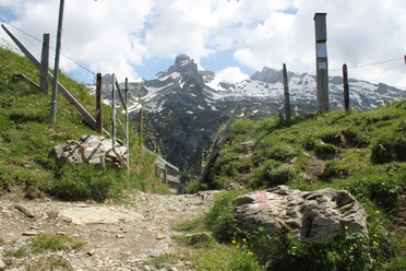
The hike leads alternately on roads, paths, and a Staldenweg uphill. The latter is listed in a 1923 trail directory of the Muothatal municipality as the only cattle trail for the northern valley side of the Starzlenbach. It shows typical features of a traditional alpine lane used by cattle. After about one and a half hours, the Schafmatt is reached. Surrounded by scree slopes, one walks on a beautifully laid path made of huge stone slabs. Further over the Bärenloch follows after just under four hours the Pragel Pass height at 1548 m above sea level.
- 6:10 h
- 18.49 km
- 964 m
- 737 m
- 626 m
- 1,550 m
- 924 m
- Start: Muotathal
- Destination: Rear Klöntal
Good to know
Pavements
Best to visit
Directions & Parking facilities
By public transport, train and boat reach the Flüelen train or boat station. The post bus or the bus line of Auto AG will take you directly to the stop at the valley station of the Biel-Kinzig cable car.
By car from the north via the A2 motorway (Lucerne-Gotthard), leave it at the Flüelen exit and follow the signs to Klausen Pass.
By car from the north via the Axenstrasse, follow the signs to Klausen Pass at the end of the Flüelen bypass tunnel.
By car from the south via the A2 motorway (Gotthard-Lucerne), leave it at the Erstfeld exit and follow the signs to Klausen Pass.
Once you have passed the village center of Bürglen from all the above-mentioned routes, you will see the parking lots of Biel-Kinzig AG (where you can park free of charge).
Author
Stoos-Muotatal Tourismus
Organization
Schwyzer Wanderwege
Nearby