Wägitalersee


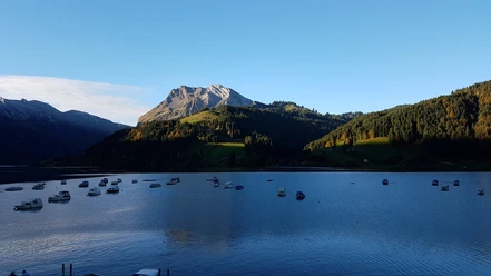
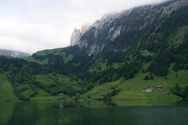
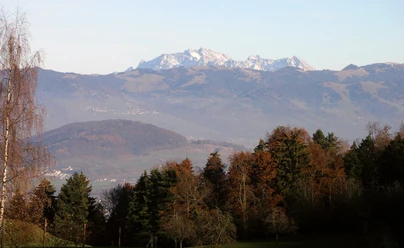
A pleasurable hike is the circuit around the Wägitalersee. The hike starts in the village of Innerthal, at the PostBus stop. Keep left towards Halten. The circuit is exclusively on the reservoir road. Although it is little trafficked, it is unfortunately fully paved. This, however, does not detract from its attractiveness. You are rewarded with a uniquely beautiful natural panorama. At Halten, there is initially a multi-family house that stands out with a large gnome landscape. After that, it is best to devote your attention again to the lake and the surrounding mountains. In the first meters towards Sännegg, Blatti, and Bruch, it is mainly Fluebrig or Diethelm with "Turner", Gantspitz, and Wännifirst that catch the eye. From time to time, it is also worth looking back north where the Gross Aubrig beckons. Shortly after Ziggen, the path leads into the forest. A nearly inconspicuous signpost on the road points to a small gem at the Wägitalersee: the Hundloch spring. You should not miss descending the few meters to lake level and visiting the spring, which resembles a grotto. You can even fully descend and enter the beautiful but damp and dripping grotto. The wonderfully clear water looks inviting. Then continue to the end of the lake. At Au, you can plan a first break to refresh or quench your thirst. Small specialties against hunger are also available. And the view from the terrace towards Schiberg, Bockmattli, and the lake is also inviting. Then continue along the back shoreline to the dam and from there back to Innerthal. Along the way, you still have a good view of the seemingly unconquerable Zindlenspitz. But that is deceptive; it can be hiked.
- 3:00 h
- 13.00 km
- 44 m
- 44 m
- 896 m
- 933 m
- 37 m
- Start: Innerthal
- Destination: Innerthal
Good to know
Pavements
Best to visit
Directions
Tour information
Barrier-Free
Familiy-Friendly
Loop Road
Nature Highlight
Stop at an Inn
Equipment
Directions & Parking facilities
By SBB to Siebnen-Wangen, then PostBus route NFB 523 SBB timetable
Additional information
Author
Erhard Gick
Organization
Schwyzer Wanderwege
Nearby
Download GPX file