WanderWunder Schwyz: Circular hike Etzel


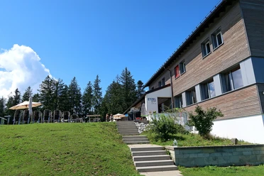
The starting point, the Etzel Pass, is also called St. Meinrad by the locals. The chapel and guesthouse also bear this name, as Meinrad, later canonized as a saint, is said to have lived as a hermit on the pass around 828. Our hike also crosses the Way of St. James at the St. Meinrad Chapel.
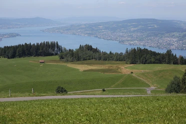
Despite the proximity to the agglomerations at Lake Zürich, the Etzel has maintained its tranquility, and the hike passes through diverse meadows, pastures, and forest areas. It starts leisurely along the forest edge with a view of the Devil's Bridge. Soon, a small raised moor with its typical birches captures the view. After mastering the following ascent and arriving at the high Etzel, you have earned a refreshment. Even if it is just the invigorating view towards Einsiedeln, Lake Sihl, and the Central Swiss mountains, or on the other side towards the Lake Zürich basin, which transitions into gentle hills. The descent to the Etzel Pass at the end is steep in places.
- 0:59 h
- 2.81 km
- 144 m
- 144 m
- 953 m
- 1,097 m
- 144 m
- Start: Etzel Pass
- Destination: Etzel Pass
Good to know
Pavements
Best to visit
Tour information
Loop Road
Nature Highlight
Stop at an Inn
Directions & Parking facilities
From Einsiedeln by post bus towards Egg. Walk up from the "Postplatz" stop.
From Pfäffikon SZ by post bus towards Feusisberg. Walk up from the "Abzweigung Etzelpass" stop.
Author
Schwyzer Wanderwege
Organization
Schwyzer Wanderwege
Nearby

Download GPX file