Weggis - Rigi Kaltbad, via Steiglen

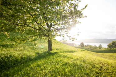
The scenic ascent from Weggis to Rigi Kaltbad leads through the impressive scenery of the Nagelfluh bands. Once at the destination, you will be rewarded with a spectacular view.
- 3:15 h
- 6.71 km
- 1,001 m
- 435 m
- 1,436 m
- 1,001 m
- Start: Weggis boat station
- Destination: Rigi Kaltbad village square
Waypoints
Good to know
Pavements
Best to visit
Directions
From the Weggis boat station we walk to the village square and turn left towards the valley station of the Weggis - Rigi Kaltbad cable car. The hiking trail continues for a short stretch on the right side of the station along the road, then over a narrow path through a meadow and woodland area until we reach Rigistrasse again. We continue right along the road. After about 700 meters, you can climb a path on the left to bypass the road bend. Soon we reach the Säntiberg hill. We follow the road, cross the Chienbach, and then turn right. After the pasture and a wooded area, the next section is already visible: a rather steep ascent in the rocky walls! The exciting path leads over steps that are safe to walk. The effort is worth it - you are rewarded with fantastic views. Then we enter open, flatter alpine terrain again. After a short steep passage through the forest, we find ourselves below the village of Rigi Kaltbad. We pass the terrace house and the new residential tower until reaching the village square of Rigi Kaltbad.
We then take the cable car back down to Weggis comfortably.
Tour information
Mountain Railway Tour
Equipment
Directions & Parking facilities
Author
Tourist Information Weggis (Luzern Tourismus AG)
Organization
Weggis Vitznau Rigi

Nearby