Wild haymaker path at Rophaien


The Uri Reuss Valley is a typical foehn valley. Many say that the warm downwind, the foehn, is the oldest Uri native. The wild hay slope at Rophaien is additionally exposed to the south. Because of this, many botanical specialties occur here. Already in the Schattigen Berge we encounter, for example, a stately cherry tree. This is extraordinary at this altitude. From here we can also see the wild hay area at Rophaien, one of the largest in Switzerland.
Now the hiking trail crosses the Gruontal, a true fairy-tale forest. Geologically, we move from flysch to limestone. Large limestone rocks have fallen down and lie here in the middle of the forest on the grey flysch.
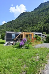
Soon the forest clears. We reach the summer grazing area at Unter Hüttenboden. These pastures are grazed by cattle for about three months in summer. In bad weather, the wild hay is supplemented. You might even discover a trist, a storage place for wild hay or litter material.
After crossing the alp, we enter the south slope. Here the slopes are called terraces. In August, alpine herdsmen and farmers come up here to the wild hay terraces at Rophaien to harvest the wild hay, a strict and dangerous work. But wild haymaking is a long tradition here. The tools for wild haymaking have been the same since time immemorial. Thanks to wild haymaking, the landscape remains open and does not become forested. Only thanks to human intervention can many orchid species survive here. The meadows belong to the most species-rich in the entire Alps.
Of course, we also let our gaze wander away from the meadows over the fascinating landscape. The best view is from Franzen, a pulpit-like alp. It is worth lingering here and having some food.
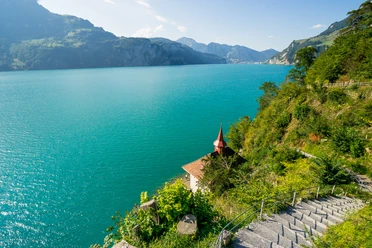
Slowly we approach the region where agriculture is practiced all year round. At Ober Axen we cross lush natural meadows. Here we can stop at the restaurant before boarding the cable car towards Flüelen. The cable car ride reveals completely different views of Lake Uri again. We enjoy the panoramic view and mentally retrace the exciting route once more.
- 2:55 h
- 7.43 km
- 263 m
- 706 m
- 996 m
- 1,545 m
- 549 m
- Start: Valley station Flüelen - Eggberge cable car
- Destination: Ober Axen
Good to know
Pavements
Best to visit
Directions
From the mountain station Eggberge we hike northwards through the Schattigen Berge to the Chaltebrunne. From the Gruontal we ascend to the alp Unter Hüttenboden. At Steinrustig the path turns into the typical wild landscape at Rophaien. Over the Plattental and the Teiftal we reach the Älpeli and finally the alp Franzen. The descent from Franzen leads over the Obere Frimseli to Ober Axen, where we safely return to Flüelen by cable car.
Tour information
Cultural Interesting
Loop Road
Mountain Railway Tour
Nature Highlight
Stop at an Inn
Equipment
Day backpack, good footwear, binoculars and camera, sun protection and rain protection.
Recommended map material:
Directions & Parking facilities
Additional information
You can also arrive the evening before and stay overnight at the mountain inn Seeblick on the Eggbergen. You will be rewarded with a unique sunrise.
Author
Markus Fehlmann
Organization
Verein Urner Wanderwege
Author´s Tip / Recommendation of the author
Bring a field guide. You will especially see many beautiful flowers from June 20th until the end of July. Information about the flora can be found at the Natural Research Society Uri.
Safety guidelines
The valleys that have to be crossed can still be filled with snow until June 20th. We must be especially careful here. Also, in autumn the railings and safety ropes have to be dismantled and rebuilt in spring. We therefore recommend doing the hike only when the wild hay path is officially open. Please note the information from the Uri Hiking Trails Association.
Map

Nearby


Download GPX file