5-hut panorama route: stage 3 Chelenalphütte SAC to Bergseehütte SAC


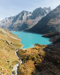
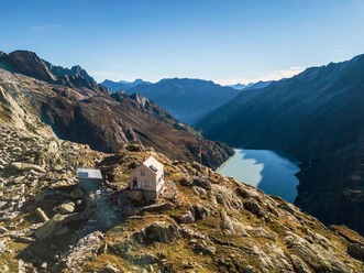
The ascent from Chelenalphütte towards Sustenlimi first crosses the sometimes wild stream and reaches shortly above Chelenalphütte, secured by some holding ropes, in steep switchbacks to the well-recognizable fork towards Bergsee. The route now leads southeast over solid scree with stony slabs and across several wild streams to a distinctive cairn at Hinter Mur. Scree and coarse blocky rock require surefootedness. Then the path leads through a ridge of the Hoch Horefellistock to Vorder Mur and then descends through only slightly different path sections down to the blue-green Bergsee. It lies still and quiet in the legendary surroundings, only the rustling of an installed tyrolienne conveys the bustle of the nearby hut. The subsequent short ascent takes hikers up to Bergseehütte.
- 2:05 h
- 5.22 km
- 363 m
- 351 m
- 2,342 m
- 2,611 m
- 269 m
- Start: Chelenalphütte SAC
- Destination: Bergseehütte SAC
Good to know
Best to visit
Directions
Chelenalphütte - Hinter Mur - Vorder Mur - Bergsee - Bergseehütte
Tour information
Nature Highlight
Stop at an Inn
Equipment
- Weather-appropriate clothing
- Good footwear
- Hiking poles are recommended
- Via ferrata set required (for the entire 5-hut route)
Directions & Parking facilities
Via Göschenen you reach the Göschenen Alp Valley. Göschenen lies directly at the A2 motorway exit.
There are parking spaces directly at the reservoir of the Göschenen Alp.
You can reach the Göschenen Alp Valley by bus, where the two huts are located. The timetable is as follows: Postauto timetable and the bus stop is the last station at the dam of the Göschenen Alp reservoir.
Additional information
Author
Andermatt-Urserntal Tourismus GmbH
Organization
Région de vacances Andermatt
Author´s Tip / Recommendation of the author
Safety guidelines
Hikers should keep an eye on the weather forecast in advance, as the hike is above 2,000 m.a.s.l. and in extreme cases there may be light snowfall.

Nearby
