Alpenkranz 1st stage: Klewenalp - Hinterjochli - Gitschenen (Isenthal)


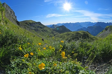
From Klewenalp NW (1593 m), which is conveniently reached by a spacious cable car from the village of Beckenried, we follow the broad mountain path to the "Alpstubli." Then the path descends to the restaurant Tannibuel (1525 m). From there, a red-white marked ascent leads us up to the Mälchgädeli (1620 m) toward Alp Stafel and further to Höch Stand (1789 m). After the Chaelenegg (1938 m), the route now climbs steeper through the Chälen to the saddle of Hinterjochli (2105 m). We hike in a wide arc downhill from Hinterjochli and find an ideal resting place "bi den Seelenen."
Then follows the descent over the Isenthaler Alp Oberbolgen (1820 m), grazed by cattle in summer, and steep switchbacks down to the Alp Unterbolgen (1657 m). Along the rock ribs of "Unter Zingel" to a mountain path, we continue through colorful alpine meadows to the mountain homestead Kneiwies (Chneuwis 1565 m). Those who want to go directly down to Isenthal hike a few more minutes to the mountain station of the LSB Isenthal - Gitschenen (1538 m). At the mountain guesthouse at the station, Berggasthaus Gitschenen, holiday guests as well as hikers and tourists are always welcome.
- Technical difficulty: T2 white-red-white
- 3:00 h
- 7.53 km
- 597 m
- 632 m
- 1,523 m
- 2,106 m
- 583 m
- Start: Mountain station of the Beckenried Klewenalp cable car
- Destination: Gitschenen in Isenthal
Good to know
Pavements
Best to visit
Directions
Klewenalp - Tannibuel - Chaelenegg - Hinterjochli - Oberbolgen - Unterbolgen - Kneiwies – Gitschenen
Tour information
Mountain Railway Tour
Nature Highlight
Equipment
- Sturdy hiking boots with grippy soles, weather-appropriate equipment, topographic national maps (not just a smartphone), compass, and altimeter belong to the basic equipment.
- Additionally, a pocket first aid kit, rescue blanket, mobile phone, or radio for emergencies also belong to the basic equipment.
- Hiking poles are very helpful in rocky terrain, especially with a heavy backpack.
Directions & Parking facilities
This stage is possible as a day stage.
Beckenried and Isenthal are both well accessible by public transport. Therefore, this hike is also suitable as a day stage. The bus stop in Beckenried is called "Beckenried, Post". From there, about a 5-minute walk will take you to the valley station of the Beckenried-Klewenalp cable car. The bus stop at the valley station of the Gitschenen cable car is called "Isenthal, Seilbahn St. Jakob".
https://www.klewenalp.ch/poi/luftseilbahn-beckenried-klewenalp
Gitschenen cable car:
Additional information
- www.alpenkranz.ch
- There are two possible accommodations at Gitschenen: Berggasthaus Gitschenen and glass igloo or wooden hut at Alptubli-Gitschenen.
- Information about the Uri adventure region can be found here: www.uri.swiss
- Book your accommodation in the Uri adventure region: www.uri.swiss/de/planen/unterkuenfte/
- Local mountain guides & qualified hiking leaders can be found at; Montanara Bergerlebnisse, Urner Bergführer Verein and Honigberg.ch
Literature
Author
Sanna Laurén
Organization
Verein Urner Wanderwege
Author´s Tip / Recommendation of the author
Tip:
Enjoy an overnight stay at Gitschenen. Take a one-hour evening walk on the "Gitschenen circular trail" via Geissboden and delight in the wonderful mountain world.
Option:
Those who want to climb even higher at the "Hinterjochli" (2105 m) and enjoy more views: the Risetenstock (2289 m) or the summit of the Schwalmis (2246 m) are available.
Safety guidelines
Mountain hiking is demanding. Knowledge of mountain dangers (rockfall, slip/fall risk, sudden weather changes) is necessary for mountain trails. Sturdy hiking boots with grippy soles, weather-appropriate equipment, topographic national maps (not just a smartphone), compass, and altimeter belong to the basic equipment. Additionally, a pocket first aid kit, rescue blanket, and mobile phone for emergencies also belong to the basic equipment.
It is recommended to make a serious tour planning and careful preparation for every hike. The weather in the mountains can change very quickly. Fog can also make orientation difficult even in summer. The biggest danger in summer, besides the heat, is thunderstorms. Thunderstorms with heavy rain and hail can quickly turn a small brook into large rivers, increasing the danger of mudslides and rockfalls. Therefore, it is important to interpret the weather report during tour planning. Warm thunderstorms often come only in the afternoon, but frontal thunderstorms can occur at any time of day. Generally, it is worthwhile to start early in summer.
Mountain guides or qualified hiking leaders (up to T4) are recommended for alpine trails (white-blue-white marked routes), hiking leaders for hikes and mountain hikes. They take over the organization & planning of tours, so guests can simply enjoy the hike.
The Urner Wanderplaner and the Uri Outdoor App help with planning.
Via Geo Admin, you can find many useful information, such as where pastures with herding dogs, mother cow pastures, and also wildlife rest zones are located.
Hikers hike at their own risk. The Urner Wanderwege association is not liable for accidents that occur during the Urner Alpenkranz hike.
Map
The hiking and biking map of the canton of Uri, Urnersee sheet, is also very informative.
The "Urnersee" sheet is available in the web shop of Urner Wanderwege: www.urnerwanderwege.ch/de/shop

Nearby


