Via Urschweiz, 3rd stage


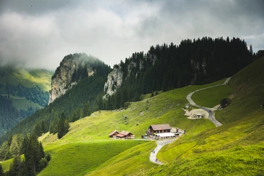
Already the trip by boat to Isleten on Lake Uri is a highlight. The postbus takes you to Isenthal, St. Jakob. The drive on the panoramic route offers breathtaking views of the mountain scenery, the Urner Reuss valley, and the Schwyz basin. The Gitschenen aerial cableway leads to the rustic high plateau. On the ascent from Gitschenen to the highest point of the ViaUrschweiz at 2105 m above sea level at Hinterjochli, the hiker is rewarded with a wonderful view of diverse habitats. The impressive backdrop of the glaciated Uri-Rotstock accompanies us. At Hinterjochli we cross the cantonal border from Uri to Nidwalden. Soon the view opens to the north over Klewenalp and Lake Lucerne. Our distant view extends out to the Central Plateau. Over alpine meadows, we soon reach Tannibühl and Klewenalp with the climbing garden, the Riccola herb garden, the marmot park, as well as restaurants and accommodation options.
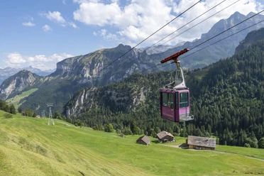
Now we have the option to continue by aerial cable car to Beckenried and by boat back to the starting point. However, there is also the possibility to hike down on foot from Klewenalp on old goods and forest roads with ever-new views of Lake Lucerne and the pre-Alps.
A swim in the lake offers a welcome refreshment on hot days.
- 5:15 h
- 14.38 km
- 639 m
- 1,743 m
- 437 m
- 2,106 m
- 1,669 m
- Start: Gitschenen
- Destination: Beckenried
Good to know
Pavements
Best to visit
Directions
Gitschenen - Chneuwis - Unter Bolgen - Ober Bolgen - Hinterjochli - Chälen - Tannibüel - Klewenalp - Eggenrüti - Tristelen - Bodenberg - Ifang - Beckenried
Tour information
Cultural Interesting
Mountain Railway Tour
Nature Highlight
Stop at an Inn
Equipment
Good mountain shoes. Daypack. Those unsure about old snow should take hiking poles.
Directions & Parking facilities
Additional information
Here you can access the Via Urschweiz website with more information.
Further information about the Alpine hike can be found here.
https://www.regionklewenalp.ch/de/aktuelles/rundreisen/alpenwanderung/
Tourist information:
Region Klewenalp-Lake Lucerne
Kirchweg 12
6375 Beckenried +41 41 624 66 01
Author
Sanna Laurén
Organization
Verein Urner Wanderwege
Author´s Tip / Recommendation of the author
You can also comfortably enjoy the descent from Klewenalp to Beckenried on the cable car. The views are fantastic here too.
Safety guidelines
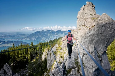
On the north side, there may still be old snowfields in spring that make the descent more difficult. Be cautious here.

Nearby

