WanderWunder Schwyz: Around the Glattalpsee


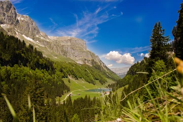
The route starts at the alpine farm Sahli. Either take the Luftseilbahn Sahli-Glattalp up or hike via Läcki, a pasture with a salt lick for livestock, past the Chneu, a hill resembling a knee. Continue over Mütschen to the junction of the SAC Glattalphütte.
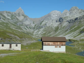
From the Glattalphütte follow the hiking signposts towards Glattalpsee. After following the gravel path for about 10 minutes, you pass the mountain farm Glattalp. Past the signpost towards "Seeloch" the gravel path leads after about fifteen minutes of walking to a side basin of Glattalpsee. Along the shore the trail is marked red and white. Always following the not always well recognizable path around the lake, you eventually reach the starting path at Seeloch and back to the mountain station of the cable car.
- 3:50 h
- 13.34 km
- 746 m
- 746 m
- 1,146 m
- 1,892 m
- 746 m
- Start: Sahli valley station Glattalp cable car
- Destination: Sahli valley station Glattalp cable car
Waypoints

Good to know
Pavements
Best to visit
Directions
Tour information
Loop Road
Mountain Railway Tour
Nature Highlight
Stop at an Inn
Equipment
Directions & Parking facilities
Take the train to Schwyz, station. Then continue with bus no. 1 to Muotathal, Post.
From there, a PostAuto drives to the Luftseilbahn Sahli-Glattalp.
PostAuto timetable: https://www.postauto.ch/de/fahrplan
Additional information
Ascent with Luftseilbahn Sahli-Glattalp shortens the hiking time by 2h
Author
Schwyzer Wanderwege
Organization
Schwyzer Wanderwege
Author´s Tip / Recommendation of the author
Safety guidelines
Nearby
Download GPX file