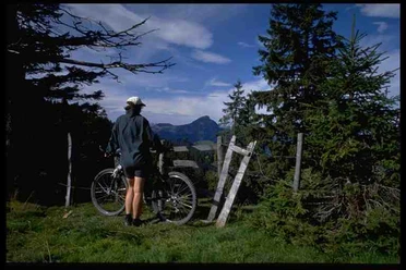
Bike circular route Rossweidhöchi


The ascent is long but manageable. First on paved side roads, later on gravel roads the path steadily goes upwards. Before the border crossing on Rossweidhöchi, you have to carry or push the bike for about 500 meters because the ground is swampy. Then the road leads first on gravel, later from Mettmen on paved road back down into the valley.
- 4:32 h
- 39.75 km
- 1,028 m
- 1,029 m
- 409 m
- 1,437 m
- 1,028 m
- Start: Valley station cable car Morgenholz-Niederurner valley
- Destination: Valley station cable car Morgenholz-Niederurner valley
Good to know
Pavements
Best to visit
Tour information
Loop Road
Stop at an Inn
Equipment
Directions & Parking facilities
The valley station of the cable car is located far west of Niederurnen at about 480m. The route is signposted, including from Niederurnen Ochsenplatz. Just follow Schul- and then Hädilochstrasse uphill.
Cooperative Cable Car Niederurnen-Morgenholz, Hädilochstrasse 48, 8867 Niederurnen GL
Parking spaces are available at the cable car station.
Author
Hannes Hochuli (Glarus Nord Tourismus)
Organization
VISIT Glarnerland AG
Author´s Tip / Recommendation of the author
Stop at the mountain restaurant Hirzli (opening hours www.niederurnertaeli.ch/restaurant-hirzli)
At the Mettmen blockhouse there is a fountain for refilling water.
Alternative along the slope without traversing the valley on dirt roads.

Nearby
Download GPX file