Biketour Seewligrat on Bürgenstock


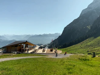
The trail leads along a forest road from Stans (Eichli sports facility) to Ober Stöckmatt. On hot summer days, the ride through a forest is particularly pleasant. At Ober Stöckmatt it is worth taking a photo break. The open view of Mount Pilatus, the Stanserhorn and towards Obwalden is tremendous.
After that it becomes flatter and you pass the Obbürgen plateau until you reach the farm at Etschenried. There you have a wonderful panorama over the other side of Lake Lucerne, all the way to the Engelberg Valley.
Finally, turn right and climb another 100 metres to the highest point of the Seewligrat. Then the downhill fun begins on the single trail. The route first leads along the rocky ledge and winds its way down through the Bürgenberg forest back to the Eichli sports facility.
- 2:00 h
- 16.29 km
- 567 m
- 567 m
- 435 m
- 1,000 m
- 565 m
- Start: Stans
- Destination: Stans
Good to know
Pavements
- Unknown (22%)Street (5%)Asphalt (9%)Trail (39%)Path (26%)
Best to visit
- suitableDepends on weather
Directions
- Stans - Ober Stöckmatt - Etschenried - Seewligrat – Stans
Tour information
Circular trail
Directions & Parking facilities
- Getting therePublic transportation
Additional information
- For tourist information:
Nidwalden Tourismus
Bahnhofplatz 2
6370 Stans
+41 41 610 88 33
[email protected]
www.nidwalden.comMore bike tours on nidwalden.com/bike
Author
Nidwalden Tourismus
Organization
Bikegenoss Zentralschweiz
Author´s Tip / Recommendation of the author
- E-MTB: well suited for e-mountain bikes
Safety guidelines
- On this tour you can expect traffic and forest work. Blockings and instructions by forest personnel must be followed.
Map
Nearby




Download GPX file