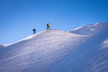
Blüemberg (2405 m a.s.l.)

Blüemberg offers a fantastic panoramic view. The descent into Muotathal with 1800 vertical meters is the longest pre-Alpine descent in central Switzerland.
Ascent / Descent
A)Normal route from Lidernenhütte. Difficulty moderate (ZS)
- Ascent / Descent: 704 m | Counter-ascent on descent: 37 m
- Starting height: 1728 m a.s.l. | Target height: 2402 m a.s.l.
- Time required for ascent: 2¾ h | Distance: 4 km
Descent
B) to Muotathal. Difficulty moderate (ZS)
- Descent: 1796 m | Counter-ascent on descent: 11 m
- Starting height: 2402 m a.s.l. | Target height: 607 m a.s.l.
- Time required for descent: 2 h | Distance: 6.9 km
- Places along the route: Rupperslauibödeli - Achslenteuffi - Wasserböden (Muotathal - SZ) - Ahöreli (Muotathal - SZ) - Riggis (Muotathal - SZ) - Hellweid (Muotathal - SZ)
Other possibilities (without track)
Descent
C) to Chäppeliberg. Difficulty moderate (ZS)
- Descent: 1246 m | Counter-ascent on descent: 37 m
- Starting height: 2402 m a.s.l. | Target height: 1193 m a.s.l.
- Time required for descent: 1½ h | Distance: 4.8 km
- Places along the route: Alt Stafel (Riemenstalden - SZ) - Hochtännli - Stafel (Riemenstalden - SZ) - Berg (Riemenstalden - SZ)
- 2:45 h
- 10.94 km
- 680 m
- 1,798 m
- 608 m
- 2,402 m
- 1,794 m
- Start: In Muotathal
- Destination: Husky-Lodge Muotathal
Good to know
Best to visit
Directions
Equipment
Good equipment and sufficient catering.
Directions & Parking facilities
By car on the A4 to the Schwyz exit, then head towards Muotathal and drive to the Husky-Lodge Muotathal.
Parking spaces are available at Erlebniswelt Muotathal.
Additional information
Husky-Lodge 041 831 81 50
Organization
Stoos-Muotatal Tourismus
Author´s Tip / Recommendation of the author
You can be chauffeured by the hotel's own shuttle bus from the Husky-Lodge hut hotel to Riemenstalden (approx. 45 min.) and enjoy the 1800 m descent directly back to the Husky-Lodge hut hotel.
Safety guidelines
Inform yourself well about the route and be sure-footed.
Ski touring routes are not marked and prepared. Enter at your own risk. Please observe the following rules of conduct on the ski tour.
Healthy and fit for the mountains
Good fitness through regular endurance and strength training. Watch out for energy reserves for the descent.
Careful route planning
Pay special attention to the weather forecast, as cold, wind, and poor visibility greatly increase the risk of accidents. Plan alternative routes and checkpoints.
Complete equipment
Standard emergency equipment includes avalanche transceiver, shovel and probe, first aid kit, bivy sack, mobile phone (Europe emergency number 112), and an airbag system.
Avalanche report
Inform yourself thoroughly about the avalanche danger before the tour! How high is the danger level, where are the danger spots, what are the current avalanche problems?
Weigh avalanche risk
Base your decisions on strategic risk assessment methods (reduction methods) and watch for danger signs in the terrain.
Orientation and breaks
It is important to master handling of maps, altimeter, compass, app, or GPS. Drinking, eating, and breaks are necessary to maintain performance and concentration.
Maintain distances
Distances serve to relieve the snow cover and limit damage. Relief distances of 10 m when ascending steep slopes also increase comfort during hairpin turns. During the descent, always maintain distances of at least 30 m and descend very steep slopes individually.
Avoid falls
Falls during descent are the most common cause of accidents on ski tours. They mean a great additional burden for the snow cover.
Small groups
Small groups (up to 6 people) increase safety. Communication with other winter sports enthusiasts and mutual consideration prevent dangerous situations.
Respect nature and the environment
Take care of wild animals, respect protected areas, and avoid entering reforestation areas. Form carpool groups or use public transport for the journey.

Nearby