Circular hike over Gibelstöcke and Seewlialp

Tip
7.96 km long
Round trip
Difficulty: medium
Condition: easy
Great panorama
Hike
  • 3:08 h
  • 7.96 km
  • 284 m
  • 1,218 m
  • 596 m
  • 1,813 m
  • 1,217 m
  • Start: Middle station of the Attinghausen-Brüsti aerial cableway
  • Destination: Middle station of the Attinghausen-Brüsti aerial cableway
A beautiful circular hike starting from the sunny terrace Brüsti over the Gibelstöcke, where we enjoy a wonderful panoramic view, down past the Seewlialp and the traditional mountain farms Regliberg and Wettmatt back to the starting point in Attinghausen.

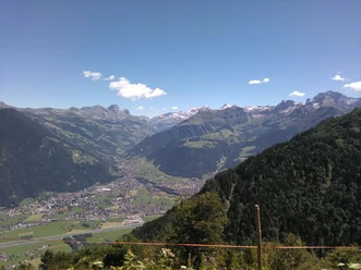
After the adventurous train ride, it is worth taking time to study and enjoy the panorama from the sunny terrace Brüsti. The path rises slowly to Nossenboden, a popular barbecue site with running water and toilet. Through the last outposts of the forest, we reach the alp area. Alp Grat is the highest point of our hike.

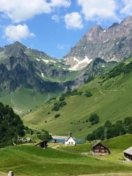
It is worth resting again and enjoying the panoramic view. Slowly, the path goes downhill towards Seewlialp. If you are lucky, you can observe deer, chamois, stags, or eagles. A short break is worthwhile at Seewlialp. Once again, we can enjoy the wild Uri mountain world, then the path goes into a romantic wild forest. We enjoy the shade and emerge at Regliberg into a large clearing, where a farm is managed in the traditional way.

Then we enter a forest again, with a completely different character, until we reach the meadows above Attinghausen at Port. From here, it is a hop back to our starting point.

Good to know

Pavements

Asphalt
Gravel
Trail
Path

Best to visit

suitable
Depends on weather

Directions

Brüsti - Nossenboden - Alp Grat - Gibelstöck - Seewliberg - Alp Seewli - Regliberg - Wettmatt - Port - Middle Station Attinghausen-Brüsti

Tour information

  • Loop Road

  • Mountain Railway Tour

  • Stop at an Inn

Equipment

Good shoes, rain protection, sun protection.

Uri hiking map, sheet Lake Uri

Directions & Parking facilities

By car, you reach the large roundabout south of Flüelen via the A2 or Axenstrasse. Here you drive towards Altdorf. In Altdorf, turn right into Bahnhofstrasse and after a few hundred meters turn left towards Attinghausen. After the next roundabout, you go under the railway and the highway. After crossing the Reuss, drive straight up the mountain. Before the next bridge, first turn right and then shortly after left. Now the road climbs steeply up to the parking lot at the middle station of the Attinghausen-Brüsti aerial cableway.
At the middle station of the Attinghausen-Brüsti aerial cableway, there are plenty of free parking spaces.
By train, you can change to the bus towards Attinghausen in Altdorf or Flüelen. The bus goes to Kohlplatz, where the valley station of the Attinghausen-Brüsti aerial cableway is located. You can transfer immediately and must change to the upper section of the cable car at the middle station.

Author

Markus Fehlmann

Organization

Verein Urner Wanderwege

Author´s Tip / Recommendation of the author

The hike only lasts a little over three hours. Take more time, especially between Brüsti and Seewlialp, and enjoy visiting the mountain inns and alpine huts.

Safety guidelines

None

Map

Uri hiking map, sheet Lake Uri

Nearby

Contact

Circular hike over Gibelstöcke and Seewlialp
6468 Attinghausen