Descent through the Bockitobel


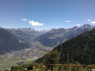
The cable car takes us almost to 1,600 meters above sea level. Here, on the sun terrace on the Brüsti, we enjoy the panoramic view. If you want, you can also play a card game in one of the mountain inns. Afterwards we descend towards the south, down into the Waldnacht nature reserve. At the small reservoir at the entrance to Bockitobel, the path goes into the gorge. In front of us rises an impressive rock face, towering vertically more than 1,000 meters over the Reuss valley.
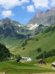
Then we pass through the Plattental. We can turn left towards Zieriberg, from where a cable car can take us down to the valley. Even nicer is the further slow descent over Wilerli - here you find a second option to return to the valley by cable car - namely into the Erstfeldertal.
Over the Hoch Weg we can hike back again to the north to Attinghausen.
- 4:44 h
- 14.35 km
- 259 m
- 1,203 m
- 453 m
- 1,529 m
- 1,076 m
- Start: Attinghausen
- Destination: Attinghausen
Good to know
Pavements
Best to visit
Directions
Tour information
Loop Road
Nature Highlight
Stop at an Inn
Equipment
Directions & Parking facilities
Additional information
Author
Markus Fehlmann
Organization
Verein Urner Wanderwege
Author´s Tip / Recommendation of the author
Safety guidelines

Nearby


Download GPX file