High-altitude hike Brüsti - Honegg


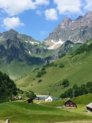
Even the train ride from Attinghausen to the sunny terrace Brüsti is an experience. Once at the top, the path rises gently. Those who want to have a coffee first will find several mountain inns at Brüsti. After a few minutes, we reach the Nossenboden fireplace area. Here we find running water and also proper toilets. Now we go up over the Kraienhöreli to Alp Grat, where we can stop at the first alpine hut. We have reached the highest point of the hike.
The descent through the Laucheren down into the Gitschental is again strenuous, but then it becomes really pleasant. We pass through the Gitschental, admire the floral splendor and the wild romantic streams before entering a beautiful mountain forest. Soon we reach an inviting picnic spot in the middle of the forest. A short break and the path continues to our hiking destination: Alp Honegg. Here we enjoy alpine cheese, meringues with "Alpänidlä," and the beautiful view. The herder family knows many exciting stories to tell.
In a few minutes, heading north, we reach another alpine farm, Gitschenberg. You can also buy cheese here. The cable car brings us back down to the valley.
Those who want to walk down can of course do so. If you want to return to the starting point at Attinghausen by foot, count on 3 hours of hiking time. From the Gitschenberg valley station, you can also walk back to Attinghausen comfortably in one hour via Bodenwald.
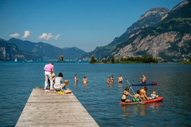
Book your accommodation in the Uri holiday region here: booking.uri.info!
- 3:03 h
- 7.88 km
- 456 m
- 613 m
- 1,303 m
- 1,828 m
- 525 m
- Start: Top station of the Attinghausen - Brüsti aerial cableway
- Destination: Top station of the Seedorf - Gitschenberg aerial cableway
Good to know
Pavements
Best to visit
Directions
Tour information
Stop at an Inn
Equipment
Directions & Parking facilities
Additional information
Author
Markus Fehlmann
Organization
Verein Urner Wanderwege
Author´s Tip / Recommendation of the author
Safety guidelines

Nearby

