From Alpnachstad via Ämsigen to Pilatus Kulm

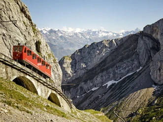
This classic hike follows the Pilatus Railway, the world’s steepest cogwheel railway. It starts at the valley station in Alpnachstad. After a short stretch along the main road, the Pilatus trail branches off to the right. The route passes beneath the railway, leads via Grossrüti (614 m) and across the Wolfort stream into the shaded Langenschwand forest, where it climbs away from the tracks in numerous switchbacks. Later, the line is crossed on the Wolfort tunnel before the trail winds up to the Ämsigen mid station, once a water stop for steam locomotives. From Alp Ämsigen, paths on both sides of the railway ascend in switchbacks to Mattalp on the left or Matt on the right. A break is worthwhile at the mysterious Chilchsteine (1,865 m) below the Matthorn (2,041 m). The mountain path then climbs across scree slopes to Pilatus Kulm.
Good to know:
The Pilatus Railway opened in 1889 and reaches gradients of up to 48 percent.
- 5:00 h
- 7.72 km
- 1,628 m
- 435 m
- 2,063 m
- 1,628 m
- Start: Alpnachstad
- Destination: Pilatus Kulm
Good to know
Best to visit
Tour information
Stop at an Inn
Equipment
Directions & Parking facilities
Author
Luzern Tourismus
Organization
Lucerne Tourisme
Author´s Tip / Recommendation of the author

Nearby