High alpine hike from Urnerboden to Klausenpass

Tip
10.20 km long
Difficulty: easy
Condition: very easy
Great panorama
Hike
  • 3:35 h
  • 10.20 km
  • 358 m
  • 522 m
  • 1,818 m
  • 2,138 m
  • 320 m
  • Start: Fisetengrad
  • Destination: Hotel Klausenpass
The first great panoramic view is experienced when we leave the mountain cable car at Fisetengrad. We can enjoy the view up to Gemsfairen. Then it gently ascends towards Claridenälpeli. Worth seeing are the rock formation "Tyfelsfrydhof" and the small glacier lake of the Claridengletscher. Across rocky high alpine terrain, we soon reach the Klausenpass. The descent to the hotel opens up a completely new view towards Urirotsock.

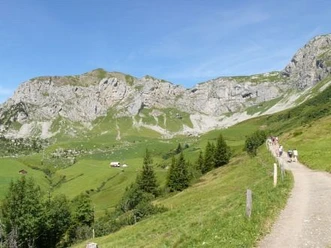
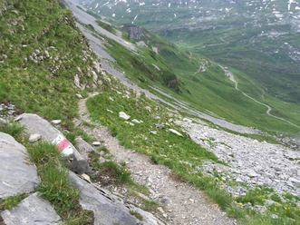
At the port on Urnerboden, we first take the mountain cable car to Fisetengrad. Here we find ourselves on the one hand amidst the most beautiful alpine flora, on the other hand, we have wonderful views to the east, north, and west. On a wide path, we comfortably reach Gemsfairen, a large cattle alpine pasture. From here, the path becomes narrower. The stone-rich alpine meadows slowly turn into stony scree. In this glacier forefield, we find pioneering plants and completely different stones that testify to the complex geological history of this area.

On the left side appears a glacier lake with a glacier tongue. With luck, we experience ice breaking noisily into the lake. Above us, the Claridennorth face rises into the sky. Already at Claridenälpeli, it goes gently downhill again to the Klausenpass.

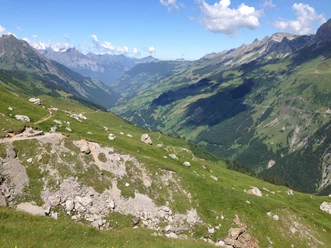
Up to Hotel Klausenpasshöhe, we cross Oberstafel of the largest cattle alpine pasture in Switzerland, Urnerboden. From the hotel's terrace, we enjoy the view to the west, where the sun sets behind Grossspannort, Brunnistock, and Urirotstock.

Good to know

Pavements

Asphalt
Trail
Path

Best to visit

suitable
Depends on weather

Directions

Fisetengrad - Gemsfairen - Claridenälpeli - Klausenpasshöhe - Hotel Klausenpasshöhe

Tour information

  • Nature Highlight

  • Stop at an Inn

Equipment

Good mountain boots, rain protection, day backpack

Recommended map material:

Uri hiking and bike map sheet "Schächental"

Directions & Parking facilities

We reach Urnerboden by car either via Glarus - Linthal or via Altdorf - Bürglen - Klausenpass.
There are many free parking spaces at the church.
We easily reach Urnerboden by post bus, from where a mountain cable car comfortably takes us up to Fisetengrad. At Hotel Klausenpass, we can directly get back on the post bus: either towards Canton Uri or Canton Glarus.

Additional information

Further information can be found on the websites of the Urnerboden and the Klausenpasshöhe.


Author

Markus Fehlmann

Organization

Verein Urner Wanderwege

Author´s Tip / Recommendation of the author

Stop at the Gemsfairen huts. Perhaps the alpine herders will find time to tell you about the alpine hut life. Enjoy the view of the wildly romantic glacier lake at the foot of the mighty Claridennorth face.

Safety guidelines

We only do the hike once the post bus drives over the Klausenpass again after mid-June. Then the bridge over the Fätschbach is securely installed. Before that, crossing the Fätsch during snowmelt is often very difficult.

Map

Uri hiking and bike map sheet "Schächental"

Nearby

Contact

High alpine hike from Urnerboden to Klausenpass
8751 Urnerboden