Hohfadweg


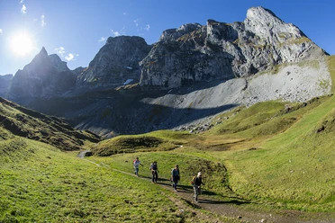
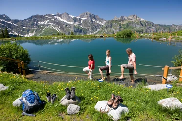
The starting point of the Hohfad hike is Engelberg railway station. Through the houses you go to the Sportingpark and further through an avenue to the Bänklialp bridge. Here the Engelberger Aa river is crossed. Along the left riverbank you follow the Professorenweg for about half an hour until the gravel road narrows and starts to ascend. Below the path, you can watch the golfers putting before the path turns right into the forest. From here it gets really steep. Occasionally steps help you master the steepest parts. Thanks to the shade of the trees, you don't start sweating after the first few steps. But it can be said in advance, the ascent is definitely worth it. Suddenly the forest clears and you stand on a high plateau. The breathtaking view of the village and the surrounding mountains makes you forget the exertion of the last 45 minutes. This place, with the Titlis north face behind you, is recommended for a picnic. Already here you can hear the next highlight of the route rushing. In the stream of the Hundsbach, small basins form, inviting you to bathe with their crystal clear water. But be cautious, the stream is fed by a glacier. The route continues to Alp Bödmen where, if you're lucky, you might encounter llamas. Here begins the descent towards Herrenrüti from where the hiking trail leads to the Fürenalp valley station. From here you have the option to take the free summer bus back to the starting point at Engelberg railway station or to hike back to the village via the golf course and the Professorenweg.
- 3:57 h
- 13.13 km
- 449 m
- 449 m
- 999 m
- 1,448 m
- 449 m
- Start: Engelberg railway station
- Destination: Engelberg railway station
Good to know
Best to visit
Directions
Tour information
Loop Road
Stop at an Inn
Directions & Parking facilities
Author
Engelberg - Titlis Tourismus
Organization
Engelberg-Titlis Tourismus
Author´s Tip / Recommendation of the author

Nearby


Download GPX file