Muotathal - Circular route Guggeli

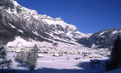
We start in Wil, the oldest part of the village of Muotathal. From the old monastery, it goes to the St. Josef monastery, where some Franciscan nuns still live and work today. In 1799 the Russian General Suworow took up quarters in this monastery when he fought the French in Schwyz. But this hike is not a battle, it is a pleasure. The road leads to Guggeli, where a break is worthwhile. The self-service broom tavern in the Gaden and its seating in the sun invite you to linger with a view of the imposing Wasserberg. This is followed by a small climb over forest areas and wild streams to the highest point of the hike, the Änzenenbänkli. Feet stand still, the gaze wanders further over the broad, flat valley floor: from Ried over Muotathal and towards Bisisthal. The gentle descent leads through open pastureland back to the monastery and finally to the starting point. The hiking trail is not signposted.
- 2:00 h
- 5.45 km
- 191 m
- 191 m
- 610 m
- 801 m
- 191 m
- Start: Wil
- Destination: Wil
Good to know
Pavements
Best to visit
Directions
Simply follow the Weather Frog hiking trail
Tour information
Familiy-Friendly
Loop Road
Stop at an Inn
Equipment
- Sturdy, winter-proof shoes with good tread, warm clothing adapted to the weather (if necessary, hat, gloves and trekking poles); possibly warm drinks.
Directions & Parking facilities
From the A4 towards Schwyz - Muotathal - Muotathal Post
Muotathal Post bus stop
Additional information
Author
Stoos-Muotatal Tourismus GmbH / Region Luzern-Vierwaldstättersee
Organization
Stoos-Muotatal Tourismus
Author´s Tip / Recommendation of the author
Bäsäbeizli & Guggeli viewpoint
Safety guidelines
- The walking and winter hiking trails are not specially signposted. After heavy snowfall, the paths may not always be cleared.

Nearby


Download GPX file