Panoramic trail Morschach


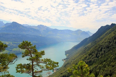
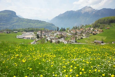
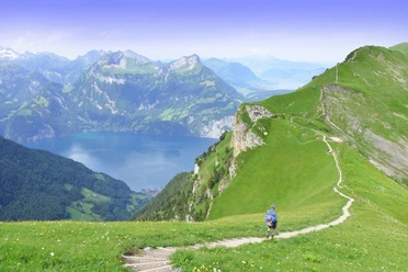
In the village center of Morschach, we start the circular hike around the village of Morschach, which first takes us on the “Path of Switzerland” towards Axenstein. Past the old route of the electric cog railway, which between 1905 and 1969 brought noble guests from Brunnen to the Morschach grand hotels, we reach the uniquely beautiful viewing terrace at Axenstein. After an extensive view of Lake Lucerne, we walk along the golf course past the restaurant open to everyone and see on the left, shortly before Schwyzerhöhe, a unique Druid stone, a so-called granite boulder, which was transported there during the last Ice Age. From Schwyzerhöhe we continue hiking to Ferienhof Rüti. Here the Schwyz basin lies at our feet and we enjoy a clear view of the Schwyz landmark: the little and big Mythen mountains with steeply falling cliffs. Via the cable car parking lot Morschach-Stoos and past Nägelisgärtli, we reach the highest point of our 2- to 3-hour hike and walk on a narrow path along the forest edge towards Dägenbalm. On the way back, we go directly down the steep Dägenbalm road to Morschach or take a small detour to the Lourdes grotto. This quiet place invites you to linger and rest briefly before walking back to Morschach. In and around the village there are many possibilities to extend the hike a little.
- 1:40 h
- 5.73 km
- 270 m
- 270 m
- 642 m
- 847 m
- 205 m
- Start: Village square Morschach
- Destination: Village square Morschach
Good to know
Best to visit
Directions
From the village center towards Axenstein to Wilgis and the Schwyzerhöhe. Then on towards Nägelisgärtli, Ried to Dägenbalm and from there back to the village center.
Tour information
Loop Road
Stop at an Inn
Equipment
Hiking shoes with a good profile or trekking shoes, rain jacket, drink, food, possibly sticks.
Directions & Parking facilities
By car on the A4 to the Mositunnel exit, then turnoff to Morschach.
Parking options in the village (payable).
Take the SBB to Brunnen station SBB timetable
Auto AG Schwyz line 502 Schwyz-Brunnen with line 504 from Brunnen to Morschach AAGS timetable
Literature
More information in the free brochure at the Morschach info pavilion:
Author
Stoos-Muotatal Tourismus / Schwyzer Wanderwege
Organization
Schwyzer Wanderwege
Author´s Tip / Recommendation of the author
Visit to the Swiss Holiday Park.

Nearby


Download GPX file