Sihl ErlebnisWeg Stage 1 – Unteriberg - Untersihl - Studen

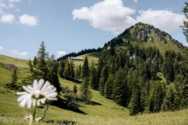
The hike starts in Unteriberg in the canton of Schwyz and follows the young Sihl, which rises here in the source area of the Schwyzer Voralpen. From the Minster, an important tributary, the Sihl Erlebnisweg first leads into the alpine area. At the Chanzel, panoramas open up into the Unter- and Obersihl, with peaks such as Lauiberg, Mieserenstock, and Höch Hund. Below these mountains lies the Sihl source in the Chrälöch, origin of the river that flows to Zurich. The steep descent over the Ofenplangg requires surefootedness and experience. From the Alp Ortegg, the path follows the course of the young Sihl through wild mountain landscape before the route leads down over Gripschli to Studen SZ. Here ends the first of seven stages of the approximately 100-kilometer multi-day hike from the source to the mouth of the Sihl.
- 5:55 h
- 15.96 km
- 917 m
- 954 m
- 892 m
- 1,834 m
- 942 m
- Start: Unteriberg bus station
- Destination: Studen SZ
Good to know
Pavements
Best to visit
Directions
From Unteriberg, it goes along the Minster up into the alpine area. After Alp Hinterofen, the view opens at the Chanzel into the source area of the Sihl. The steep descent over the Ofenplangg leads to Alp Ortegg, from where the path follows the young Sihl all the way to Studen.
Tour information
Nature Highlight
Summit
Equipment
- Sturdy hiking boots with tread
- Hiking poles for the descent
- Weather-appropriate clothing (rain protection, sun protection)
- Enough drinking water and provisions, as there is no catering on the way
Directions & Parking facilities
Since this stage hike has a different destination, it is recommended to travel by public transport.
General information for overnight guests
Hotel guests in the Einsiedeln district receive the Einsiedeln-Ybrig public transport card at check-in, which provides free use of local public transport (bus/PostAuto) in tariff zones 679–685.
Stage 1: Unteriberg – Studen
- Arrival: With PostBus line 555 from Einsiedeln via Unteriberg/Oberiberg – optimal starting point.
- Return: From Studen by line 553 back to Einsiedeln.
- With public transport card: Both bus rides are covered within zones 679–685.
Author
Stefan Bisig
Organization
Einsiedeln-Ybrig-Zürichsee
Safety guidelines
- Steep descent over the Ofenplangg: surefootedness required.
- In rain or wet conditions, increased risk of slipping on grassy slopes.
- Last kilometers run on hard surfaces – watch out for traffic.

Nearby