Unteriberg, circular hike Spital-Regenegg


You start at the Guggelstrasse bus stop at Minsterplatz 928 m above sea level in Unteriberg. Follow the signpost to “Nidlau/Spital”. After a short hike, you reach the Nidlau residential area and come to the Nidlaubach with the suspension bridge built in 2015. On the other side of the stream are four wooden sculptures created by local artists. A short detour across the bridge is worthwhile.
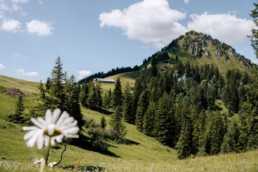
Back again, follow the signposts to Spital via Blätz and Adler. Here you also encounter several wooden sculptures along the hiking trail in the forest. After Adler, the hiking trail leads mostly on a gravel road almost to the Spital hut before switching to an alpine meadow.
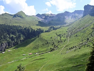
Upon reaching Spital at 1574 m above sea level, you can learn the names of the surrounding peaks nearby and far away from the viewing pictogram.
Take the path towards Regenegg. In the marshy meadow, wooden bridges ensure easy passage. At Regenegg 1531 m above sea level, the second point with a wonderful view of the Ybrig mountain world is reached.
Our circular route first leads you over the alpine meadow, then through the forest in Schatteneggen. After crossing the road, continue through the forest until you reach Höchgütschstrasse.
From Spital, it is also possible as an option to continue hiking to Gross, Euthal, or Einsiedeln in about two hours.
- 3:56 h
- 10.87 km
- 702 m
- 700 m
- 921 m
- 1,573 m
- 652 m
- Start: Unteriberg, Guggelsstrasse
- Destination: Unteriberg, Guggelsstrasse
Good to know
Pavements
Best to visit
Directions
Tour information
Loop Road
Stop at an Inn
Equipment
Directions & Parking facilities
Organization
Region Ybrig
Author´s Tip / Recommendation of the author
Map

Nearby

Download GPX file