Small Melchaa Gorge


The hike starts from Giswil station heading first towards Sachseln. After crossing the newly laid Melchaa, the path winds through the forest up to the viewpoint. Once at the top, an exceptionally beautiful view surprises you.
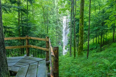
After another short ascent, the path reaches Tobelsträsschen. On the Melchaaboden begins the entrance to the gorge. Far below, the water of the small Melchaa rushes, forcing its way through narrow, old glacial mills and passages with many small deep-blue rapids. The trail continues through very tight passages with high vertical rocks, directly along the wild stream. Past Bettlernest and the tricky path with the dome, the hiking trail finally reaches the power plant facility of the Obwalden Electricity Works. Here the two tunnels join, which lead the water from the large Melchtal further into Lake Lungerer.
The hike ends at the Rindenhüttli.
In winter, the Tobel is a magical landscape with beautiful huge icicles! During the winter months, the hike leads back to Giswil via Cholplatz on the path through the Grossmattwald and past the customs house.
Variant
In summer, a hiking trail through the small Melchtal also leads to Älggialp (geographical center of Switzerland).
- 3:29 h
- 10.95 km
- 493 m
- 493 m
- 484 m
- 977 m
- 493 m
- Start: Giswil station
- Destination: Giswil station
Good to know
Pavements
Best to visit
Tour information
Loop Road
Directions & Parking facilities
From Lucerne, take the tunnel onto the A8 towards Interlaken, change at Sarnen and then continue on the A8 to Giswil.
From Interlaken via Brünig on the A8 to the Giswil exit.
Author
Obwalden Tourismus
Organization
Obwalden Tourismus

Nearby
Download GPX file