Spirstock


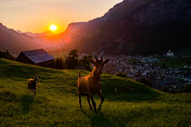
The hike starts in the small mountain village of Illgau with a cable car ride from Illgau to St. Karl. Before the start, enjoy the view of the Fronalpstock and the Muotatal mountain world. The short route to Oberberg is enough to absorb the calmness and gentleness of the landscape and to switch off. Away from busy paths, the hike continues to Chaltenbrunnen, Eseltritt and up to the first viewpoint: the Sternenegg. The two Mythen mountains tower impressively into the air and dominate the panoramic view.
From the Sternenegg, the hike steadily ascends gently over sunny gravel and field paths. Cows graze in the alpine meadows and jingle their bells. After the Laucheren chapel, it gets a bit steeper until the ascent to the Spirstock is behind us. From the second viewpoint on the route, we turn once around our own axis and let the view wander far over Lake Lucerne and Lake Zurich until it is magically drawn again to the Mythen mountains.
On the way back, you hike over the Fäderenberg, Ober Hasen, and take the path in Unter Zimmerstalden to the mountain station of the Illgau - St. Karl aerial cableway. The route ends after the descent by cable car in the village of Illgau.
- 4:40 h
- 14.12 km
- 1,014 m
- 651 m
- 816 m
- 1,766 m
- 950 m
- Start: Village of Illgau
- Destination: Village of Illgau
Good to know
Pavements
Best to visit
Directions
Illgau - Vorder Oberberg - Chaltenbrunnen - Eseltritt - Sternenegg - Spirstock - Fäderenberg - Ober Hasen - Unter Zimmerstalden - Vorder Oberberg - Illgau
Tour information
Loop Road
Mountain Railway Tour
Stop at an Inn
Summit
Equipment
Hiking shoes with good soles or trekking shoes, rain jacket, drink, food, possibly poles.
Directions & Parking facilities
By car on the A4 to the Schwyz exit, then towards Muotathal to the valley station of the Ried-Illgau aerial cableway or by car towards Muotathal, follow the signs to Illgau after the valley station of the funicular.
From Illgau continue with the Illgau - St. Karl aerial cableway.
Additional information
Please note the schedules of the Illgau-Ried cable car and the Illgau - St. Karl cable car.
Literature
Information about the hike can be found in the following brochures:
Author
Stoos-Muotatal Tourismus / Schwyzer Wanderwege
Organization
Schwyzer Wanderwege
Author´s Tip / Recommendation of the author
Take a break on the panoramic terrace of the Oberberg restaurant.
Safety guidelines
Surefootedness and good endurance.
Map
Further information about the hike can be found in the Schwyz hiking map:
Nearby

Download GPX file