Urwaldweg Bödmeren


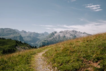
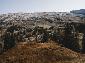
Already at the starting point Eigeliswald on the Pragelpass road, slender, deeply furrowed spruces and the terrain interspersed with karren (limestone rocks) characterize the landscape. The mosaic of forest and meadow accompanies us throughout the path. Humans have created alpine pastures there by clearing, where the soil was suitable. In the Stägen to the east begins the primeval forest reserve (www.boedmeren.ch). We see a spruce forest structured by small tree clusters and later a light, shrub-rich birch forest with individual spruces and pines. The flora reacts very sensitively to soil conditions and micro-topography, resulting in great diversity. The alp meadow marks the end of the primeval forest.
- 3:15 h
- 10.23 km
- 315 m
- 315 m
- 1,375 m
- 1,688 m
- 313 m
- Start: Eigeliswald
- Destination: Eigeliswald
Good to know
Pavements
Best to visit
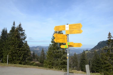
Directions
The starting point is Eigeliswald on the Pragelpass road: After a short path, we enter the meadows of Mittenwald and turn east at the first junction towards Bödmeren. In the Stägen we choose the uphill path heading east. Shortly before the saddle, we turn south towards Tor, reach the highest point of our hike after the Alp Bödmeren, and continue westwards towards Äbnenmatt. After a short stretch on the alp road, we again cross a primeval landscape.
Through the alp areas of Äbnenmatt and Chalbertal, we reach another pass. Directly on the path lies a Flösch (small moor). The Alp Ober Saum was inhabited year-round until 1958. Passing impressive deep views into the Muotatal, we return to the starting point.
Tour information
Loop Road
Nature Highlight
Equipment
Sturdy footwear or trekking shoes, rain jacket, drink, provisions, possibly poles
Directions & Parking facilities
Muotathal is located in Central Switzerland and is easily accessible by car.
From Basel-Lucerne:
Continue on the A14 from Lucerne towards Zug. After 20 km, you reach the Rütihof junction. Take the A4 motorway towards Schwyz. Take the Schwyz exit and follow the signs to Muotathal. Follow the main road through the entire village of Muotathal. At the Höll-Loch restaurant, take the right turn towards Pragelpass. Drive to the Eigeliswald parking lot.
From Lake Constance and Rapperswil:
At Rapperswil, drive towards Pfäffikon / Gotthard. In Pfäffikon, briefly drive on the A3 motorway towards Gotthard. Then take the first exit towards Gotthard / Schwyz. The road leads via Rothenthurm and Sattel to Schwyz. In Schwyz, drive towards Muotathal. Follow the main road through the entire village of Muotathal. At the Höll-Loch restaurant, take the right turn towards Pragelpass. Drive to the Eigeliswald parking lot.
From Gotthard-Altdorf:
Take the bypass (tunnel) in Flüelen towards Schwyz. After the Mosi tunnel, exit the motorway at exit 40 Brunnen (towards Weggis/Gersau/Schwyz/Brunnen). Drive towards Ibach/Schwyz and at the 2nd roundabout in Ibach (near Dany's Family Restaurant), take the first exit towards Muotathal. Follow the main road through the entire village of Muotathal. At the Höll-Loch restaurant, take the right turn towards Pragelpass. Drive to the Eigeliswald parking lot.
Accessible by public transport only up to Muotathal.
By train to Schwyz station. From there by bus No. 1 to Muotathal to the bus stop "Muotathal, Hölloch".
From there, take the Pragel taxi to Eigeliswald. Tel. 041 830 11 81 (please call in advance)
Additional information
Wanderland route 826
Literature
More information about the route in the free brochure at the Stoosbahn stations:
Author
Stoos-Muotatal Tourismus / Schwyzer Wanderwege
Organization
Schwyzer Wanderwege
Author´s Tip / Recommendation of the author

Nearby
Download GPX file