ViaSuworow Stage 6: Biel-Chinzig – Muotathal


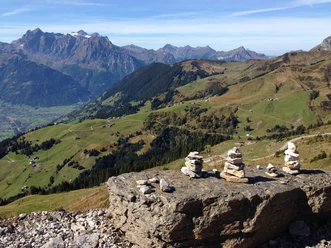
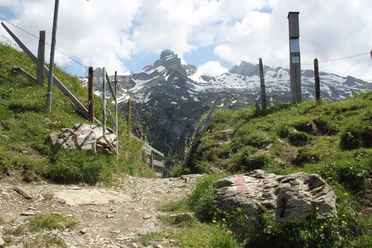
Coming from Italy, the Russians crossed the Ticino border at Ponte Tresa, crossed Monte Ceneri, through the Leventina and over the Gotthard Pass, then advanced to Ursern and through the Reuss Valley to Altdorf. The French resistance at Lake Uri and in the Glarus lowlands forced Suworow to make detour marches over the passes Chinzig Chulm and Pragel and finally to retreat through the Sernftal and over the Panixer Pass into the Surselva. The Russian troops left the area of the former Three Leagues towards Russia through the Rhine Valley. Suworow memorials on the Gotthard and in the Schöllenen recall these dramatic events, as do the general’s accommodations in listed buildings such as the Muotathal monastery or the Suworow house in Elm. In addition to the historical sites along the route, the unique natural scenery impresses. Wild mountain valleys, pass landscapes, mountain lakes and rivers can be enjoyed without worry - especially when thinking of Suworow’s troops, who had to cover the route under time pressure, enemy attacks and the onset of winter.
- 5:00 h
- 14.46 km
- 560 m
- 1,550 m
- 626 m
- 2,073 m
- 1,447 m
- Start: Biel, Altdorf
- Destination: Hinterthal, Muotathal
Good to know
Best to visit
Directions
Biel - Chinzig - Chinzig Chulm - Vordersten Hütten - Lipisbüel - Hinterthal
Tour information
Nature Highlight
Stop at an Inn
Equipment
Hiking shoes with good tread or trekking boots, rain jacket, drink, provisions, possibly poles.
Directions & Parking facilities
You can reach the Flüelen train or boat station by public transport train and boat. The post bus or line bus of Auto AG takes you directly to the stop at the valley station of the Biel-Kinzig cable car.
By car from the north via the A2 motorway (Lucerne-Gotthard), leave at the Flüelen exit and follow the signs for Klausenpass.
By car from the north via the Axenstrasse, at the end of the Flüelen bypass tunnel follow the signs for Klausenpass.
By car from the south via the A2 motorway (Gotthard-Lucerne), leave at the Erstfeld exit and follow the signs for Klausenpass.
After you have passed the village center of Bürglen from any of the above routes, you will see the parking lots of Biel-Kinzig AG (where you can park free of charge).
Additional information
SwitzerlandMobility No. 55
Literature
Free brochures with information about the path are available at the Stoosbahn stations.
Author
Stoos-Muotatal Tourismus / Schwyzer Wanderwege
Organization
Stoos-Muotatal Tourismus
Author´s Tip / Recommendation of the author
Suworow Bridge

Nearby