Zieblen


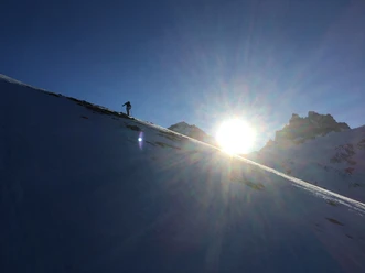
The distinctive triangle on the Hahnen can be seen especially well from the village of Engelberg. In good visibility, the turns can be admired from the village. From the Restaurant Schweizerhaus it goes through the forest via lower and upper Zieblen to the open triangle up to point 1909. The descent then follows generally towards the Restaurant "Ende der Welt".
- 2:13 h
- 7.74 km
- 881 m
- 874 m
- 1,022 m
- 1,903 m
- 881 m
Good to know
Best to visit
suitable
Depends on weather
Equipment
The equipment can be rented from the sports shops in Engelberg.
Directions & Parking facilities
Getting there
By car, take the A2 (Basel-Gotthard) to Stans Süd, then 20 km on the main road to Engelberg. Engelberg is 30 minutes from Lucerne, 1 hour and 15 minutes from Basel, Zurich or Bern.
Parking
Paid parking is available in Engelberg.
Public transportation
National and international connections (from Zurich Airport connections every half hour with about 1 hour travel time) to Lucerne. Then take the Zentralbahn in 43 minutes through varied landscapes and gorges up to Engelberg.
Additional information
Author
Engelberg - Titlis Tourismus
Organization
Engelberg-Titlis Tourismus
Safety guidelines
Safety tips for ski tours in open terrain
- Please note that you are traveling at your own risk
- A ski tour must be carefully planned.
- Appropriate equipment (avalanche transceiver, probe, shovel, airbag) and clothing are essential safety factors
- The local ski and mountain guides will safely lead you to your destination and back home
- Emergency number REGA 1414
Nearby