Alpenpanorama route stage 8: Einsiedeln – Unterägeri


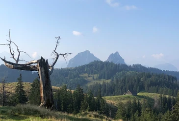
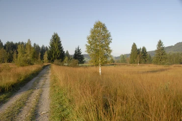
The pre-Alpine route starting in the monastery village of Einsiedeln runs along an old pilgrimage trail towards the canton of Zug. The route begins with a gentle ascent to the Chatzenstrick Pass above Einsiedeln. From Chatzenstrick, you enjoy a wonderful view of the Schwyz Alps. After a short descent to Rothenturm, you reach the next highlight of the route, the famous Rothenturm raised bog. From the natural paradise, there is a strenuous ascent to the Raten. Even on the pass located in the canton of Zug, you enjoy a rewarding view. The last section of the route descends into the Ägerital to the charming Ägerisee.
- 5:45 h
- 19.04 km
- 648 m
- 804 m
- 726 m
- 1,208 m
- 482 m
- Start: Einsiedeln train station
- Destination: Unterägeri center
Good to know
Best to visit
Directions
Einsiedeln train station - up to Chatzenstrick - continue to Rothenturm - through the Rothenturm raised bog - up to the Raten - longer descent towards Ägerisee to Unterägeri - destination at the Unterägeri center bus stop
Tour information
Cultural Interesting
Stop at an Inn
Equipment
Sturdy footwear (hiking boots)
Directions & Parking facilities
To Einsiedeln / SZ:
- Take exit no. 39 (Schindellegi) from the A3 motorway from Chur or exit no. 37 (Richterswil) from Zurich.
- From Lucerne, Zug, Schwyz, Gotthard to Schwyz and then via cantonal road no. 8 via Sattel - Rothenthurm - Biberbrugg to Einsiedeln
Brüel Parking Garage in Einsiedeln (paid) - location
To Einsiedeln / SZ:
accessible by train and bus
From Unterägeri / ZG back to Einsiedeln / SZ:
Author
Einsiedeln-Ybrig-Zürichsee Tourismus
Organization
Einsiedeln-Ybrig-Zürichsee

Nearby


