Chilcherberge-Seewlisee-Unterschächen


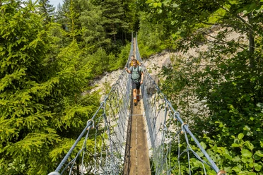
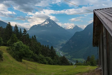
Fortunately, you can overcome the first few altitude meters with the cable car from Silenen to Chilcherberge, because many altitude meters are still ahead. After the steep ascent from Chilcherberge to Seewlisee, you are rewarded with a magnificent landscape around Seewlisee. Then continue to Seewligrat from where you descend into Griesstal. After crossing Griesstal, you stand at the far end of Brunnital. From there, the path runs gently downhill to Unterschächen.
- 5:45 h
- 14.96 km
- 1,155 m
- 1,320 m
- 994 m
- 2,246 m
- 1,252 m
- Start: Mountain station cable car Silenen-Chilcherberge
- Destination: Unterschächen
Good to know
Pavements
Best to visit
Directions
Tour information
Mountain Railway Tour
Nature Highlight
Stop at an Inn
Equipment
Sturdy hiking boots with grippy soles, weather-appropriate equipment, topographic maps (not just smartphone), compass, and altimeter are part of the basic equipment.
In addition, a pocket first aid kit, emergency blanket, and mobile phone for emergencies are part of the basic equipment.
Directions & Parking facilities
The Silenen-Chilcherberge cable car is easily accessible by public transport. As is the return trip from Unterschächen.
Additional information
Accommodation near Seewlisee: the Alp uf den Bielen and Seewlisee!
Dining at the Brunnibeizli is worthwhile: http://www.alp-sittlisalp.ch/verpflegungs--und-uebernachtungsmoeglichkeiten/brunnibeizli.html
Information about the Uri adventure region can be found here: www.uri.swiss
Book your accommodation in the Uri adventure region: www.uri.swiss/de/planen/unterkuenfte/
Author
Priska Herger
Organization
Verein Urner Wanderwege
Author´s Tip / Recommendation of the author
Don't forget swimwear but be careful not to swim too far out (underground outflow)
Passionate anglers try their luck in Seewlisee.
The animal puzzle trail invites you to solve riddles on the way through Brunnital.
Safety guidelines
Mountain hiking is demanding.
For mountain hiking trails, knowledge of dangers in the mountains (rockfall, slipping/falling hazards, sudden weather changes) is necessary. Sturdy hiking boots with grippy soles, weather-appropriate equipment, topographic maps (not just smartphone), compass, and altimeter are part of the basic equipment. In addition, a pocket first aid kit, emergency blanket, and mobile phone for emergencies are part of the basic equipment.
It is recommended to conduct a serious route planning and careful preparation for every hike. The weather in the mountains can change very quickly. Fog can also make orientation difficult even in summer. The biggest danger in summer besides heat is thunderstorms. Thunderstorms with heavy rain and hail can quickly turn a small brook into large rivers and increase the danger of mudslides and rockfall. Therefore, it is important to interpret the weather report when planning the route. Warm thunderstorms often come only in the afternoon, but frontal thunderstorms can occur at any time of day. In general, it is advisable to start early in summer.
Mountain guides are recommended for alpine hiking trails (white-blue-white marked routes).
Hiking leaders are recommended for hikes and mountain hikes; they take over organization and planning so guests can simply enjoy the hike.
The Uri hiking planner and the Uri Outdoor app assist with planning. Via Geo Admin, you can find many useful pieces of information such as where pastures with herd protection dogs, mother cow pastures, and also wildlife conservation zones are located.
Hikers hike at their own risk. The Uri hiking trails association is not liable for accidents that occur during this hike.
Map

Nearby