Circular route Kerns-Flüeli-Ranft-Kerns


The hike starts at the Kerns post office. At the corner of the house you will find the yellow hiking trail signs. I follow the sign «Flüeli-Ranft». Now it goes through Sidernstrasse and further to the next signposts, always marked «Flüeli-Ranft». After the Chalcherli landfill, a small pass leads to Wandelen, then you walk cross-country and later on a small street to Chäppeli. Soon you reach the Hohe Brücke, the border between Kerns and Sachseln.
The Ranft gorge is deep and impassable, which the Melchaa has carved on its way from the Melch valley into Lake Sarnen. For centuries, people had to bypass this barrier or climb down on a dangerous, arduous path and then climb up on the other side. The gorge is associated with a famous name: Niklaus von Flüe, the peacemaker, was born in Flüeli-Ranft and later went into the gorge where he lived in solitude. Niklaus von Flüe is one of the most influential leading figures in Swiss history. Chapels on both sides of the gorge commemorate the famous saint.
The first bridge over the Melchaa was only built in 1893. The current one is 30 meters long and spans 100 meters above the river across the gorge. The «Hohe Brücke» between Kerns and Flüeli-Ranft is the highest covered wooden bridge in Europe.
After the Hohe Brücke you are quickly in Flüeli. From the house where Niklaus von Flüe lived as a farmer, family man and councilor, an asphalted path leads down into the Ranft. Instead of this, use the gravelled official hiking trail. You will find it thanks to the large hiking signpost in the main square. It points in the direction of Stans. Additionally, the green numbers 4 (Jakobsweg), 2 (Trans Swiss Trail) and 571 (Bruderklausenweg) indicate the way. Until St. Anton, follow these signposts.
Behind the Ranft chapel, there is a pedestrian bridge over the Melchaa. The path leads up past the Müslikapelle to the church of St. Niklausen. The free-standing bell tower as well as the interior of the church with medieval frescoes and the rural baroque painted vault ceiling are worth seeing. In St. Niklausen you have the option to take the post bus and shorten the hike by about an hour.
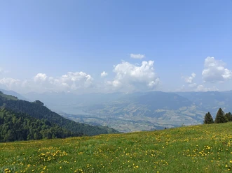
Soon after the Bethanien Dominican monastery, you can enjoy the dreamlike view over the Sarneraatal and Lake Sarnen from the Egg. A shortcut would lead more directly from Schärpfi to Burgholz. At the chapel of St. Anton you leave the SwitzerlandMobile path marked with green stickers and descend via Burgholz to the village of Kerns.
- 3:30 h
- 12.20 km
- 390 m
- 390 m
- 536 m
- 832 m
- 296 m
- Start: Kerns Post
- Destination: Kerns Post
Good to know
Pavements
Best to visit
Tour information
Loop Road
Author
Obwalden Tourismus
Organization
Obwalden Tourismus

Nearby
Download GPX file