Flower and Avalanche Educational Trail Chilchenberg


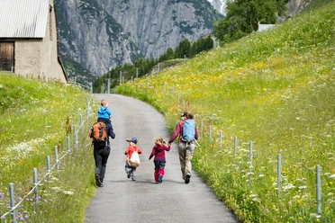
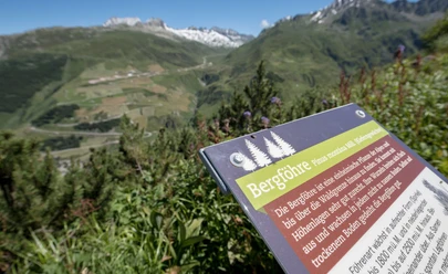
The educational trail starts next to the valley station Nätschen. From here, you hike up to the protective forest, which offers a magnificent view of the valley. Along the path, hikers find illustrations that provide extensive knowledge about the lush flora. The tasks of the protective forest are also explained. Through the protective forest, you then leisurely walk along the beautiful hiking trail. On the way, there are stunning views of the Urserntal as well as several rest areas for a break. The destination of the trail is Nätschen station.
- 1:30 h
- 3.68 km
- 448 m
- 41 m
- 1,436 m
- 1,883 m
- 447 m
- Start: Andermatt station
- Destination: Nätschen station
Good to know
Pavements
Best to visit
Directions
Tour information
Mountain Railway Tour
Nature Highlight
Stop at an Inn
Tour with Dog
Equipment
- Weather-appropriate clothing
- Good footwear
- Daypack
- Trekking poles are recommended
Directions & Parking facilities
Andermatt is very well accessible from all four cardinal directions in summer and therefore a pleasant starting point.
In Andermatt, directly behind the station, there is a large parking lot. It is located only about a 10-minute walk from the starting point of the route.
Andermatt is the connecting point of the Matterhorn Gotthard Bahn and is therefore very easily accessible by train. The timetable is as follows: SBB timetable
Upon reaching the destination, Nätschen, you can easily take the train or the gondola back to Andermatt.
Additional information
Author
Andermatt-Urserntal Tourismus GmbH
Organization
Région de vacances Andermatt
Author´s Tip / Recommendation of the author
- Very beautiful in autumn months (moss and mushrooms)
- Return with the Gütsch-Express or the Matterhorn Gotthard Bahn
- Samichlaus-Hüsli directly on the path
Safety guidelines
- Spring and autumn: Observe wildlife rest zones
Pay attention to weather forecasts. In the Alps, weather changes can occur quickly.
Nearby


