


- 1:40 h
- 21.05 km
- 424 m
- 397 m
- 688 m
- 1,008 m
- 320 m
- Start: Lungern station
- Destination: Lungern station
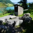
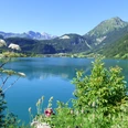
From the Brünig, it continues on low-traffic side roads to the idyllic Chäppeli. A break here is worthwhile: besides the opportunity to refresh yourself, the place impresses with breathtaking views of the Obwalden mountain panorama and the municipality of Lungern.
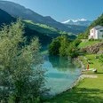
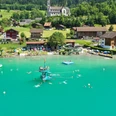
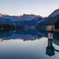
The route then heads downhill back towards Lungern and circles the steel-blue Lungerersee. The path along the lake offers numerous barbecue spots and frequent opportunities to stop for refreshment, making the route attractive even for connoisseurs.
This varied circuit is excellent for gravel bikes but can also be easily ridden with an MTB or e-MTB. Scenic and gastronomically rewarding – a perfect route for an active day in nature.

Waypoints
Good to know
Best to visit
Tour information
Loop Road
Stop at an Inn
Author
Obwalden Tourismus
Organization
Obwalden Tourismus
Nearby