Pirmin trail Langis


The high plateau of the Schlierertal Valley is a secret tip for nature lovers: The Langis area is accessible by post bus from Sarnen and offers about 50 kilometers of groomed trails. It is located directly at the pass height of the Glaubenberg Pass, which leads to the Entlebuch. From the Langis parking lot, cross-country skiers reach the starting point for all trails about 300 meters away. After mastering the ascent of about 20 meters in altitude, the cross-country ski area lies at your feet. Above, the mountain range is dominated by Titlis, Hochstollen, and the Wetterhörner.
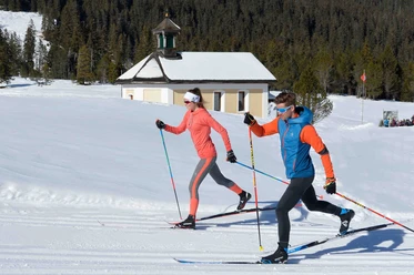
The Pirmin trail towards Fröschenseeli is rather flat in the first half and crosses a slightly wooded area. First past the Andresen hut, it goes towards Schwendi-Kaltbad with its Madonna chapel. This chapel recalls the “cold bath in Schwendi.” At the beginning of the 17th century, a shepherd boy is said to have seen a limping deer dip its leg in the water and come out healthy. Over the years, a well-known spa developed here, attracting more and more sick people hoping for healing from the iron-rich spring. In 1970, the renowned spa hotel burned down. An outbuilding was converted into a pub in the style of a Canadian log cabin.
Before we deserve a break, the trail makes three more loops in the terrain and then crosses the Schlieren. This is followed by an ascent, then a leisurely section, optionally with a visit to Schwendi-Kaltbad. After that, about two kilometers remain to the finish.
- 1:35 h
- 5.90 km
- 60 m
- 60 m
- 1,409 m
- 1,469 m
- 60 m
- Start: Start/finish area Langis
- Destination: Start/finish area Langis
Good to know
Best to visit
Directions & Parking facilities
From Lucerne/Interlaken use the A8 exit Sarnen North. From Sarnen follow the signs towards Glaubenberg Pass.
A paid parking lot is available.
In good weather on weekends, the parking lot can be full by 10:00 a.m.
By train of Zentralbahn from Lucerne/Interlaken to Sarnen and from there by post bus to Langis.
Additional information
Winter season:
The winter season usually lasts from the end of November to the end of April
Snow report:
Current information on snow conditions can be heard daily at +41 (0)41 675 11 46.
Signposting:
All trails are displayed and marked on an overview board in the start/finish area. The Fröschenseeli trail is well marked on the terrain.
Ski rental and trail pass:
Information about the local trail pass, rental of cross-country equipment, and changing and shower facilities can be found on the Langis trail website.
Author
Obwalden Tourismus
Organization
Obwalden Tourismus
Nearby