Ridge hike Stanserhorn-Engelberg


The start of this hike is already spectacular: From Stans, the world’s unique double-decker CabriO cable car takes you up to Stanserhorn – with wind in your hair and panoramic views of the Alpine paradise. At almost 1,900 m above sea level, you are rewarded with a breathtaking 360-degree view – the perfect prelude to this scenic ridge hike.
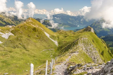
The descent first leads to the Ächerlipass and after a relaxed section the ascent to the Arvigrat begins. The path winds through the mystical Arvi forest, past roots and over steeper passages, until at over 2,000 m above sea level you are rewarded with a magnificent panorama: Engelberg valley, Sarner valley and the surrounding Alps are within reach!
The route continues over the scenic Gräfimattgrat towards Schingrat and Wagenleis. Here awaits the key section of the tour: a spectacular rock notch with rope protection – only for those sure-footed and without fear of heights!
The route then continues via the Schluchigrat and the Lachengrätli to Storeggpass. At the idyllic Lutersee, a rest is worthwhile – the perfect place to gather new energy for the last ascent. This leads to the highest point of the route, the „Bocki“ at 2,155 m above sea level.
The descent to Engelberg requires concentration again: steep but rewarding. Along the way, the alpine cheese dairy and the Untertrübsee restaurant invite you for a hearty break – before the last section leads gently down into the valley.
- 11:15 h
- 26.40 km
- 1,507 m
- 2,371 m
- 995 m
- 2,159 m
- 1,164 m
- Start: Stanserhorn
- Destination: Engelberg
Good to know
Pavements
Best to visit
Directions
Equipment
- good footwear
- enough provisions
You can find the appropriate equipment in Engelberg's sports shops.
Directions & Parking facilities
Additional information
The ridge hike is part of the Tell Trail (Stage 5). The Tell Trail is a long-distance hiking trail and passes through the picturesque Lucerne-Lake Lucerne region – from Altdorf to the Brienzer Rothorn. In eight stages, it goes past sparkling mountain lakes, through historic villages and world-famous towns, as well as to the "Big 5" of the Central Swiss mountains: Rigi, Pilatus, Stanserhorn, Titlis and Brienzer Rothorn. The diverse flora and fauna and the spectacular mountain panorama are constant hiking companions. More information: www.luzern.com/telltrail
Author
Engelberg - Titlis Tourismus
Organization
Engelberg-Titlis Tourismus
Author´s Tip / Recommendation of the author
This route is long, spectacular – and ideal for a microadventure! If you don’t want to do it all in one day, you can wonderfully plan it as a two-day route with a tent overnight stay at Alp Laucheren. A true nature experience including sunrise over the ridges.
More info: engelberg.ch/gratwanderung
Route variants for those who prefer it a bit shorter:
Shortcut from Lutersee:
If you prefer it more relaxed, turn off at Lutersee towards Alp Zingel and hike back to Engelberg.
7.2 km | approx. 2.5 h | 72 m ascent | 812 m descent
On the Buiräbähnli:
In the Engelberg valley you will find numerous charming small cable cars – so-called Buiräbähnli. They are perfect if you only want to do part of the hike.
- From Storeggpass to Eggen: 2 km | 40 min | 326 m descent
- From there you take the Buiräbähnli via Rugisbalm down to Mettlen (CHF 9.– one way).
- Then: 1.9 km on foot to Grafenort train station (30 min, flat)
- And then by train back to Engelberg (15 min).
Safety guidelines
Mountain hiking trail information:
Mountain hiking trails are mostly steep, narrow and partly exposed. Sure-footedness, a head for heights, good physical condition and mountain experience are required. Sturdy shoes with a grippy sole are necessary.
- At Wagenleis, also called "Charren", is the key section of the hike. This requires good sure-footedness and a head for heights. For safety, ropes are provided to hold on to.
- Special care is needed in rain as the path is partly steep and slippery.

Nearby

