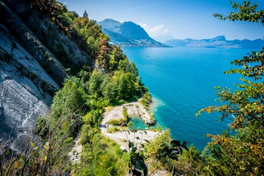
Romantic hike above Lake Uri


By boat, we reach the mysterious cradle of the Swiss Confederation: the Rütli meadow. From here we hike through a romantic landscape heading north. Soon we arrive at the historic youth hostel Seelisberg. The view stretches over Lake Uri, the Fronalpstock to the two Mythen and further to the Urmiberg. As soon as the path turns west around the ridge, the view opens towards Rigi and Lucerne with the Pilatus. We reach the hamlet of Volligen. The restaurant has one of the most beautiful viewing terraces in all of Central Switzerland. We continue hiking through alpine meadows and a primeval forest to Beckenried.
- 4:42 h
- 13.17 km
- 574 m
- 587 m
- 435 m
- 742 m
- 307 m
- Start: Rütli
- Destination: Beckenried
Good to know
Pavements
Best to visit
Directions
Tour information
Cultural Interesting
Stop at an Inn
Equipment
Recommended map material:
Directions & Parking facilities
Additional information
Literature
Erika Flückiger-Strebel, Martino Frölicher: Around Lake Lucerne - Waldstätterweg and Way of Switzerland, Albert-Köchlin Foundation, ISBN 978-3-03818-048-7
Organization
Verein Urner Wanderwege
Author´s Tip / Recommendation of the author
The Waldstätterweg, which leads from Brunnen around the entire Lake Lucerne to the Rütli, was reopened in May 2015. You can find more information on the Waldstätterweg website.
Map
Urner Wanderwege | Uri hiking and biking map, Lake Uri
https://www.urnerwanderwege.ch/de/shop?&id=1078
https://www.uri.swiss/de/highlights/geschenkideen-aus-der-erlebnisregion-uri/

Nearby


