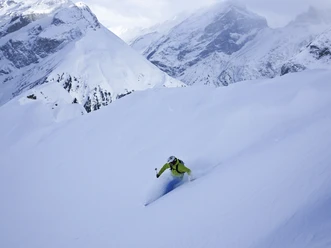
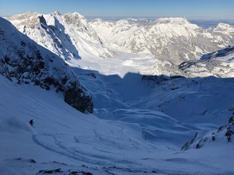
Steintäli

The descents around the "Steintäli" from the mountain station of the Jochstock Express partly lead almost to the Engstlensee. If you traverse or ascend westwards towards Wendenlücke, freeriders will find little-tracked terrain even days after snowfall.
Notes
- Difficult route finding for variants below Wendenlücke!
- Descent from 2564m above sea level to 1890m above sea level
- It is recommended to hire a mountain guide.
- 0:07 h
- 2.05 km
- 576 m
- 1,931 m
- 2,507 m
- 576 m
- Start: Jochstock
- Destination: Engstlen chairlift
Good to know
Best to visit
suitable
Depends on weather
Directions
Jochstock - Engstlen chairlift
Equipment
The equipment can be rented at the sports shops in Engelberg.
Directions & Parking facilities
Getting there
By car, take the A2 (Basel-Gotthard) to Stans Süd, then 20 km on the main road to Engelberg. Engelberg is 30 minutes from Lucerne, 1 hour and 15 minutes from Basel, Zurich or Bern.
Parking
Parking spaces are available in Engelberg for a fee.
Public transportation
National and international connections (from Zurich Airport connections every half hour with approx. 1h travel time) to Lucerne. Then by Zentralbahn in 43 minutes through varied landscapes and gorges up to Engelberg.
Additional information
Author
Engelberg - Titlis Tourismus
Organization
Engelberg-Titlis Tourismus
Author´s Tip / Recommendation of the author
Safe snow fun in the powder at the Snow & Safety Days.
Safety guidelines
Safety tips for freeriding in the open terrain
- Please note that you are on your own risk.
- A descent must be carefully planned.
- Appropriate equipment (avalanche transceiver, probe, shovel, airbag) and clothing are essential safety factors.
- The local ski and mountain guides will safely bring you to your destination and back home.
- Emergency REGA phone number 1414.

Nearby