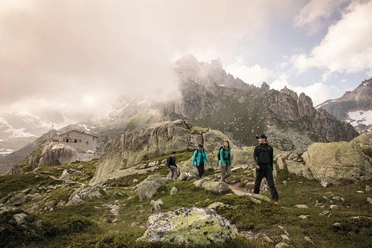
Furka Höhenweg (Urschner Höhenweg)


The hike begins at Hotel Tiefenbach. Here the path ascends up to Tätsch. Soon you reach the highest point at Gespenderboden. The wide hiking path narrows but remains easy to walk. At Lochbergegg, above Realp, you can see the protective forest which shields the village from avalanches.
Hikers cross Lipferstein and arrive at a beautiful resting spot at Blauseeli, where about half of the hike is completed. Next to Blauseeli, there are many more small crystal-clear mountain lakes inviting you to cool off.
The route continues about three kilometers straight towards Bäz. The view towards Furka, Gotthard, and Oberalp passes is breathtaking along this stretch.
The descent begins via Hospental. A short section leads over a narrow path to Moos. From there, a wide and beautiful hiking path leads along the golf course towards Andermatt.
- 5:40 h
- 15.79 km
- 421 m
- 1,091 m
- 1,431 m
- 2,309 m
- 878 m
- Start: Tiefenbach
- Destination: Andermatt Train Station
Good to know
Pavements
Best to visit
Directions
Tour information
Nature Highlight
Tour with Dog
Equipment
- Clothing appropriate for the weather
- Good footwear
- Hiking poles are recommended
- Camera
- Day backpack
Directions & Parking facilities
You can drive by car to Tiefenbach via the Furka Pass road. However, it is recommended to drive to Andermatt by car and take the Postbus from there to Tiefenbach, as otherwise, after the hike, you still have to go uphill by bus and the bus does not run very regularly.
There is a limited number of parking spaces at Tiefenbach. In Andermatt, there is a large parking lot directly at the train station and thus at the Postbus stop.
You can reach Tiefenbach from Andermatt by Postbus. Take the bus towards Furka Pass. The timetable is as follows: Postbus Timetable
Additional information
If you have any more questions, feel free to contact: Andermatt holiday region, +41 41 888 71 00, [email protected]
Author
Andermatt-Urserntal Tourismus GmbH
Organization
Région de vacances Andermatt
Author´s Tip / Recommendation of the author
- Picnic at Blausee or another mountain lake like Lutersee
- Hiking in the opposite direction is also possible
Safety guidelines
On the section down to Hospental, be aware of mountain bikers coming down the hill at some speed. This is a note so you don’t get startled and just briefly step aside from the path to let bikers pass.

Nearby


