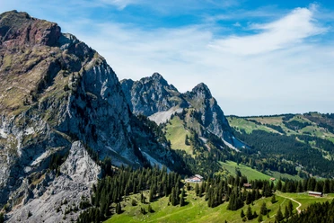
Mythen circular route


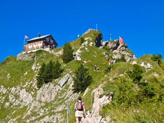
You start at the Holzegg mountain station, walk towards Haggenegg, and via G�nzigs, Hasli back to Holzegg. During the hike, you always have the "Gross" and "Chli" Mythen in view, whether behind, beside, or in front of you. Additionally, from Haggenegg downwards, you walk a short stretch on the "Jakobsweg". For hunger and thirst, there are opportunities to pause at Skihaus Holzegg, Berggasthaus Holzegg, Alpwirtschaft Zwischet Mythen, and Berggasthaus Haggenegg. The hike leads through the "Mythenbann", the oldest protected hunting area in Switzerland from the year 1492, where, depending on the season, wild animals like chamois, eagles, and marmots can be seen.
- 3:30 h
- 9.32 km
- 454 m
- 454 m
- 1,083 m
- 1,414 m
- 331 m
- Start: Holzegg
- Destination: Holzegg
Good to know
Pavements
Best to visit
Directions
Holzegg 1405 m above sea level - Haggenegg 1414 m above sea level - G�ntrigs 1122 m above sea level - Hasli 1115 m above sea level - Holzegg 1405 m above sea level.
Tour information
Loop Road
Mountain Railway Tour
Nature Highlight
Stop at an Inn
Tour with Dog
Equipment
Shoes with good tread or trekking shoes, rain jacket, drink, provisions, possibly poles.
Directions & Parking facilities
By private car from Einsiedeln about 15 minutes. Through Einsiedeln via Alpthal to Brunni, you reach the valley station of the Brunni-Holzegg cable car at the end of the road.
A large parking lot (subject to fees) is available to you.
By bus from Einsiedeln station to Brunni-Alpthal. The bus stop is called Brunni Talstation LBH. It is the final stop of this line.
Timetable cable car Brunni-Holzegg.
Author
Erlebnisregion Mythen
Organization
Schwyzer Wanderwege

Nearby


Download GPX file