Panorama circular route Wirzweli

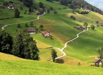
From the starting point Wirzweli (1,227 m above sea level) a gentle climb leads up to the Wirzweli Horn (1,471 m above sea level). The path over the Wirzweligrat impresses with a magnificent panorama and ends at the idyllically located Gummenalp (1,579 m above sea level). Here you can linger wonderfully – whether to rest or for a short detour to the nearby viewpoint.
Then the path leads over blooming alpine meadows gently downhill to Rohne, further to Dürrenboden and finally to Alp Langboden (1,304 m above sea level). The return route is leisurely along the Wetterhexenweg, which leads directly back to the Wirzweli mountain station.
- 3:10 h
- 9.78 km
- 409 m
- 409 m
- 1,204 m
- 1,579 m
- 375 m
- Start: Wirzweli mountain station
- Destination: Wirzweli mountain station
Waypoints
Good to know
Pavements
Best to visit
Directions
Tour information
Loop Road
Directions & Parking facilities
The access route leads via the A2 motorway in the direction of Gotthard -> exit Stans South -> Engelbergertal -> after about 5 km turn right into the village of Dallenwil -> signpost Wirzweli to the large car park Input for navigation: Wiesenbergstrasse 25, 6383 Dallenwil
Many parking spaces at the valley station of the Dallenwil-Wirzweli aerial cableway
Travel comfortably and safely by public transport. Take the SBB to Lucerne, then continue with the Zentralbahn to Dallenwil, then change to our own free shuttle bus or walk (15 minutes) to the valley station of the Dallenwil-Wirzweli aerial cableway.
Author
Nidwalden Tourismus
Organization
Nidwalden Tourismus

Nearby


Download GPX file