Pfaff

The route begins at Saliboden, directly behind the small Saliseeli. Here are the first facilities of the Schwyz district electricity plant - a technical testimony to the early use of alpine hydropower. Soon after, you cross the bridge over the rushing Rousalpbach in Tröli before following the alpine road. The natural road winds uphill in several hairpin turns to the elevation marker at point 1280, where the path turns left.
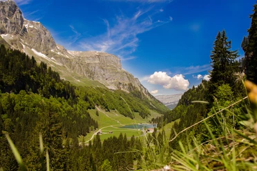
Now the actual mountain trail begins: It meanders through the landscape in further switchbacks and opens up the view to a first high plateau. In front lies the Milchbüelen alp, behind it towers the imposing rock wall of the Glattalp. To the right rise the rugged peaks of the Mären, to the left the massive Hängst.
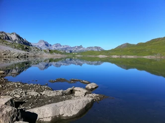
At the height of Mütschen, you pass through a typical karst landscape - wild, bizarre and fascinating - before finally reaching the wide, impressive plateau of the Glattalp.
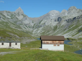
What is offered up here is a panorama of superlatives: In winter, Glattalp is considered the coldest spot in Switzerland, and in summer it transforms into an extensive alpine pasture framed by an impressive backdrop of distinctive peaks. Particularly striking are the Höch Turm and the Ortstock - the latter still towers over its neighbor by about 51 meters despite the optical illusion. To the left sits the Gross Chilchberg, while the Pfaff lies in the valley front - a worthwhile destination for hikers. The right mountain range is dominated by the Mären, the Signalstock, and the Jegerstöck.
Past the chapel and the SAC hut, the path leads directly to the viewpoint "Pfaff". From there you can enjoy views of the surrounding mountain peaks. The return is via the same route or conveniently by the Sahli-Glattalp cable car.
- 5:10 h
- 11.79 km
- 924 m
- 924 m
- 1,147 m
- 2,061 m
- 914 m
- Start: Sahli
- Destination: Pfaff
Waypoints

Good to know
Pavements
Best to visit
Tour information
Mountain Railway Tour
Nature Highlight
Stop at an Inn
Summit
Equipment
Hiking boots with good tread or high trekking boots, rain jacket, drink, provisions, possibly poles.
Directions & Parking facilities
By car from Schwyz follow the signs to Muotathal. From there head towards Bisisthal to Sahli.
Parking available at the valley station of the cable car.
Take the SBB to Schwyz-Seewen station. Then take the Auto AG Schwyz line 501 from Schwyz to Muotathal, Post. From there take line 506 to Bisisthal, Sahli cable car station.
Additional information
Descent from Glattalp by cable car, please observe the schedule. Sali-Glattalp Cable Car
Detour to the SAC hut Glattalp SAC hut Glattalp
Author
Stoos-Muotatal Tourismus
Organization
Stoos-Muotatal Tourismus
Author´s Tip / Recommendation of the author
Nearby