Seedamm path wooden bridge, Pfäffikon SZ - Rapperswil SG

The first section mostly leads over wide gravel paths through a tranquil landscape that makes every nature lover's heart beat faster. Up to Hurden, you wander with views of wide, open meadows and fields that stretch flat to the shore of Lake Zurich. From the start, the shimmering Lake Zurich complements the fascinating panorama.
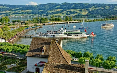
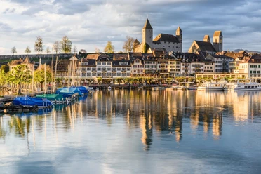
In Hurden, there is an opportunity to take a break at the attractively designed large rest area. Afterwards, you follow the Seedamm shore over charming small footbridges past magnificent reed fields. From Hurden to Rapperswil SG, you then enjoy the extraordinary view from an impressive wooden footbridge that is attractively integrated into the landscape. The footbridge leads into Rapperswil SG into a beautiful park that leads into the town. The idyllic Rapperswil SG invites you to linger by the lake, where you can perfectly conclude the route by observing ships and the activity on the water.
- 1:15 h
- 4.82 km
- 27 m
- 21 m
- 402 m
- 412 m
- 10 m
- Start: Pfäffikon SZ
- Destination: Rapperswil SG
Good to know
Pavements
Best to visit
Directions
From Hurden to Rapperswil SG, we walk along a wooden footbridge. The planks of the footbridge are arranged longitudinally to the walking direction and have a spacing of 2cm each. In Rapperswil SG, a short section leads over gravel through a park. The path from the park to the station is paved. After the underpass at the end of the park, there is a 30m long incline of 8%.
Tour information
Barrier-Free
Cultural Interesting
Familiy-Friendly
Nature Highlight
Stop at an Inn
Directions & Parking facilities
Additional information
Condition for wheelchair users: difficult
Author
Erhard Gick
Organization
Schwyzer Wanderwege
Nearby