Zingel route


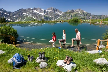
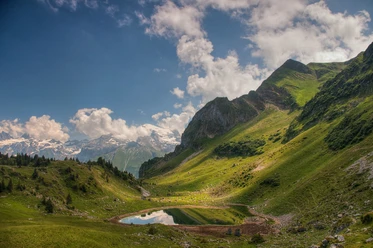
The start of this route is at Grafenort station. First, you walk along a flat forest path along the Engelberger Aa to the valley station of the Buiraebähnli, which takes you to the Rugisbalm. From here, you can also use another little train to spare your legs for the further ascent. After covering the first approx. 800 meters of altitude by train, you continue under your own power to the Lutersee. At the small lake, a picnic is recommended or you can descend a little towards Zingelalp, where a beautiful rest area with a great view and a cool drink awaits you. The further descent goes down a narrow forest path, which requires some concentration, to the Arnibach gorge. A farm ice cream from the farm shop Aeschboden sweetens the last stretch of the way to Engelberg station.
- 5:15 h
- 15.30 km
- 1,246 m
- 815 m
- 567 m
- 1,750 m
- 1,183 m
- Start: Grafenort station
- Destination: Engelberg station
Waypoints
Good to know
Pavements
Best to visit
Directions
Grafenort - Mettlen - Rugisbalm - Eggen - Lutersee - Zingel - Staldeli - Oertigen - Engelberg station
Tour information
Mountain Railway Tour
Stop at an Inn
Equipment
Stable hiking shoes, sun protection, a snack, and hiking poles are recommended.
Directions & Parking facilities
By car, take the A2 (Basel-Gotthard) to Stans Süd, then follow the main road about 12 km to Grafenort.
Above the Grafenort inn you have the possibility to park your car.
National and international connections (from Zurich Airport every half hour with about 1 hour travel time) to Lucerne. Afterwards, you can reach Grafenort station in half an hour by Zentralbahn.
Author
Engelberg - Titlis Tourismus
Organization
Engelberg-Titlis Tourismus
Author´s Tip / Recommendation of the author
The Zingel route is also the first stage of the Buirebähnli Safari.
More information about this experience can be found at the following link: Buiraebähnli - Safari

Nearby