Tell Trail Stage 1: Altdorf - Muotathal


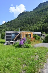
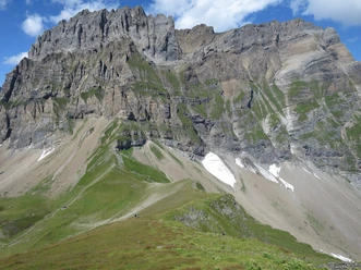
Arrival in Altdorf and luggage drop-off. By post bus you travel to Bürglen with a subsequent cable car ride to Ruogig. The first section of the Tell Trail leads you along the Via Suworow over the Chinzig Pass. The Chinzig Pass impresses with bizarre rock formations and the view of the Alpine range in the Chinzer and Hürital valleys. The hiking trail continues through the Wängital, framed by peaks, and then along the Hüribach stream into the Muotathal.
Hiking time: 5.5 hours, distance: 18 km (excluding cable car & bus sections), ascent: 556 m (with cable cars: 1,636 m), descent: 1,468 m
- 5:30 h
- 22.36 km
- 1,616 m
- 1,447 m
- 458 m
- 2,073 m
- 1,615 m
- Start: Tell Monument Altdorf
- Destination: Village Entrance Muotathal
Good to know
Pavements
Best to visit
Directions
Arrival in Altdorf and luggage drop-off. By post bus you travel to Bürglen with a subsequent cable car ride to Ruogig. The first section of the Tell Trail leads you along the Via Suworow over the Chinzig Pass. The Chinzig Pass impresses with bizarre rock formations and the view of the Alpine range in the Chinzer and Hürital valleys. The hiking trail continues through the Wängital, framed by peaks, and then along the Hüribach stream into the Muotathal.
Tour information
Mountain Railway Tour
Stop at an Inn
Summit
Equipment
Good hiking shoes.
Directions & Parking facilities
By train to Flüelen, then by bus to the Tell Monument in Altdorf.
Or with the Tellbus directly from Lucerne to Altdorf.
Additional information
This stage is part of the long-distance hiking trail Tell Trail, which runs through the entire Lucerne-Lake Lucerne region in eight stages.
More information about the Tell Trail at www.luzern.com/telltrail
Documents
Organization
Lucerne Tourisme
Safety guidelines
T3 demanding mountain hiking.
- Good surefootedness
- Average orientation skills
- Basic alpine experience

Nearby


